
Annapurna Circuit Trek

The Annapurna Circuit Trek (ACT) Nepal, is one of the world’s most famous long-distance treks, offering breathtaking Himalayan landscapes, diverse cultural experiences, and high-altitude adventure!
ACT takes you on a journey from lush tropical rainforests, to arid high-altitude plateaus, culminating in crossing the highest navigable pass in the world - The Thorang La Pass (5,416m / 17, 769ft).
In Part 1
I’ll provide you with a comprehensive overview of the Annapurna Circuit Trek, including itinerary, preparation tips and advice, cost estimates, accommodation, and other essential information.
In Part 2
Follow my adventures in my extensive diary, as i take you through what it’s actually like trekking the Annapurna Circuit Trek day to day!
All photos are my own unless stated
CONTENTS
PART 1
Guide to the Annapurna Circuit Trek (ACT)
Introduction to the Annapurna Circuit Trek
What and where is the Annapurna Circuit Trek?
Trekking route to ACT (Nepal)
Itinerary - Day-to-day
How tough Is the Annapurna Circuit Trek?
Challenge factors
Fitness needed
The Good News!
Annapurna Circuit Trek vs Everest Base Camp Trek
How much does it cost to do the ACT trek?
Cost breakdown
Annapurna Circuit Trekking Permits
Choosing Travel Insurance
The Ideal time of Year to trek to ACT
My Top Tips to Completing the Trek to ACT
Preventing Altitude Sickness on ACT
Diamox - Do i need it? Should I take it?
Drink plenty of water
Eat well and as often as you can
Slowly, slowly, catchy monkey
Daily health check
Positivity is the key to success
Kit List
Packing Tips
PART 2
BLOG: My Diary - 27th March to 16th April 2025
Day 1 to Day 4
Day 1 to Day 2: London to Kathmandu
Day 3: Kathmandu, and many meetings
Day 4: The Road to Tal
A Day to Day Trekking Guide
Day 5: Tal to Bagarchap via Dharapani
Day 6: Bagarchap to Chame
Day 7: Chame to Upper Pisang
Day 8: Upper Pisang to Manang
Day 9: Acclimatisation Day
Day 10: Manang to Sri Kharka
Day 11: Tilicho Base Camp
Day 12: TILICHO LAKE (4,919m)
Day 13: The trail to Yak Kharka
Day 14: Thorang Phedi Base Camp
Day 15: To Muktinath via the THORANG LA PASS (5,416m)
Day 16: Descent to Jomsom
Day 17: Fly/Drive to Pokhara
Day 18: Fly/Drive to Kathmandu
Day 19: Kathmandu exploration day
Day 20: Kathmandu to Mumbai, India
Day 21: Mumbai to London
SUMMARY
My YouTube video highlights!

PART 1
Guide to the Annapurna Circuit Trek (ACT)
Introduction to the Annapurna Circuit Trek (ACT)
The Annapurna Circuit Trek is one of the most iconic and scenic trekking routes in the world, located in Nepal, within the Annapurna mountain range of the Himalayas. Here's a breakdown of what and where it is:
The Annapurna Circuit Trek
A long-distance trekking route that circumnavigates the Annapurna Massif.
Known for its diverse landscapes, cultural richness, and dramatic elevation changes.
Typically takes between 12 to 20 days, depending on the starting/ending points and side trips.
Reaches an altitude of 5,416 meters (17,769 ft) at Thorong La Pass, one of the highest trekking passes in the world.
Where is it?
Located in central Nepal, within the Annapurna Conservation Area.
The trek usually starts in Besisahar or Ngadi (about 6–8 hours from Kathmandu by road), or Tal (a further drive by jeep) and ends in Jomsom or Pokhara.
Major landmarks along the route include:
Manang – A picturesque high-altitude village.
Tilicho Lake - Often opted via a side trek, at an altitude of 4,919m
Thorong La Pass – The highest point of the trek.
Muktinath – A sacred pilgrimage site for both Hindus and Buddhists.
Jomsom – A popular end point, accessible by road or flight.
Photo taken by Hannah, en route from Chame to Upper Pissang

Why it's famous
Offers panoramic views of Annapurna I, II, III, IV, Dhaulagiri, Machapuchare (Fishtail), Manaslu, and other peaks.
Passes through lush subtropical forests, alpine meadows, rocky high mountain deserts, and ancient villages.
You'll experience multiple climate zones and cultural transitions, from Hindu lowlands to Tibetan-influenced highlands.
Trekking route to ACT (Nepal)
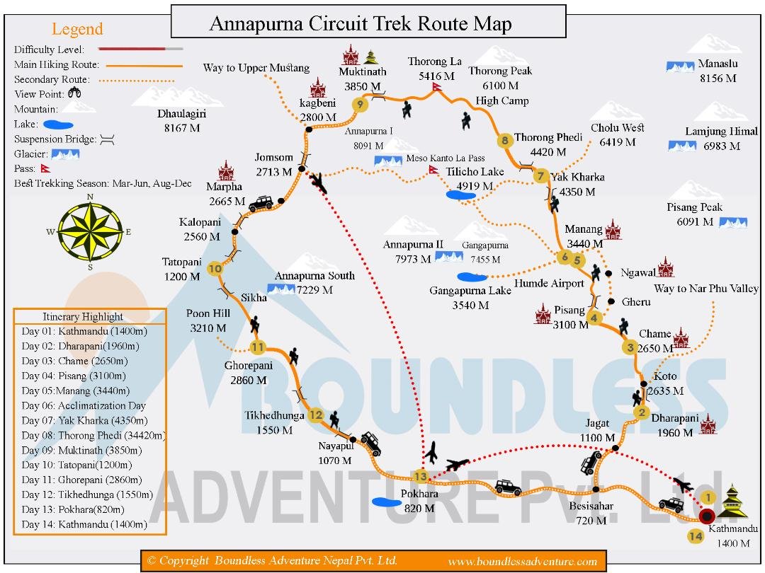
My trekking route from Tal to Jomsom
My Itinerary - Day-to-day
Route Overview
Duration: 16 nights / 17 days
Distance: Approximately 145 km
Highest Point: Thorong La Pass at 5,416m
Start: Tal (after driving from Kathmandu)
End: Jomsom (with a flight to Pokhara)
Day-by-Day Itinerary Highlights
Day 1: Arrive in Kathmandu, meet your group, and enjoy a welcome dinner.
Day 2: Drive to Tal via Besisahar, passing through lush river valleys and terraced farmland.
Day 3: Begin trekking from Tal to Bagarchap (2,160m), walking through the Marshyangdi River valley and forests.
Day 4: Trek to Chame (2,670m), passing waterfalls and mixed forests, with views of Manaslu Peak.
Day 5: Ascend to Upper Pisang (3,300m), crossing the Marshyangdi River and enjoying panoramic mountain views.
Day 6: Trek to Manang (3,540m) via Ghyaru and Ngawal, experiencing arid landscapes and Tibetan-influenced villages.
Day 7: Acclimatisation day in Manang; optional hikes to Gangapurna Lake or the Himalayan Rescue Association.
Day 8: Trek to Sri Kharka (3,880m), passing through barley fields and juniper forests.
Day 9: Hike to Tilicho Base Camp (4,150m), navigating exposed rocky slopes with stunning views.
Day 10: Early morning trek to Tilicho Lake (4,919m), one of the highest lakes globally, then return to Sri Kharka.
Day 11: Trek to Yak Kharka (4,050m), rejoining the main Annapurna Circuit trail.
Day 12: Ascend to Thorong Phedi Base Camp (4,450m), preparing for the pass crossing.
Day 13: Cross Thorong La Pass (5,416m) and descend to Muktinath (3,750m), a sacred pilgrimage site.
Day 14: Trek to Jomsom (2,720m) via Kagbeni, following the Kali Gandaki River through the world's deepest gorge.
Day 15: Fly to Pokhara and celebrate the trek's completion.
Day 16: Return to Kathmandu.
Unique Features
Tilicho Lake Extension: An adventurous detour to one of the world's highest lakes, offering serene beauty and fewer crowds.
Cultural Immersion: Experience the transition from Hindu lowlands to Tibetan-influenced highlands, visiting monasteries and traditional villages.
Scenic Diversity: Traverse subtropical forests, alpine meadows, and high-altitude deserts, with panoramic views of peaks like Annapurna II and Gangapurna.

Tilicho Lake: Photo credit to Luxury Holidays Nepal
How tough Is the Annapurna Circuit Trek?
The Annapurna Circuit Trek is considered moderate to challenging, depending on your experience, fitness level, and how well you acclimatise to high altitude. It’s very doable for fit hikers with a bit of preparation, but here's a full breakdown so you can see where the tougher bits are:
Challenge Factors
Altitude
The highest point is Thorong La Pass (5,416m)—this is the main challenge.
You’ll feel the effects of altitude (shortness of breath, fatigue), and there's a risk of altitude sickness.
Most people build in 1–2 acclimatisation days, especially in Manang, to adjust.

Distance & Duration
145–180 km total (depending on where you start/end and side trips like Tilicho Lake).
Trekking 5–7 hours per day on average, for 12–18 days.
Some long and sustained climbs—up to 1,000m elevation gain in a day.
Thorong La Pass (5,416m)
Biggest single day challenge: crossing the pass involves a pre-dawn start and 6–10 hours of hiking, including steep ascent and descent.
Often snow-covered, windy, and cold—even in peak season.
Weather
In peak seasons (Oct–Nov, Mar–Apr), the weather is generally stable.
Off-season (monsoon or winter) brings risks like landslides or snow-blocked trails.
Carrying Gear
Most trekkers use guides and porters or keep packs light. Carrying your own full pack will definitely make the trek harder.
Fitness Needed
You don’t need to be a mountaineer—but you should be:
Cardiovascularly fit (can hike 6–8 hours a day)
Comfortable with multi-day treks
Able to handle altitude and steep terrain
If you’re active (trail running, cycling, gym, or regular hikes), you’ll probably be fine with a couple months of preparation.
The Good News
No technical climbing required
Teahouse lodging means no camping—hot food, basic beds, and showers along the way
Trails are well-established and you’re rarely more than a few hours from the next village
Annapurna Circuit Trek vs Everest Base Camp Trek (including Gokyo Lakes)

Ooh…That’s a great question!
From personal experience having completed both treks, i’ve included the extension to Gokyo Lakes on the EBC trek, as that compares more closely to the Annapurna Circuit Trek, both in duration, altitude, and difficulty.
Annapurna Circuit Trek vs Everest Base Camp (EBC) Trek with Gokyo Lakes is a classic matchup, and each has its own vibe, challenges, and highlights. Here's a breakdown to help you choose (or maybe like me you’ll decide to do both someday).
Scenery & Landscape
Annapurna Circuit
One of the most diverse treks in the world
Subtropical forests → pine woodlands → alpine desert
Views of Annapurna I–IV, Dhaulagiri, Manaslu, Tilicho Peak
EBC + Gokyo Lakes
High alpine from start to finish
Epic views of Everest, Lhotse, Ama Dablam, Cho Oyu
Gokyo Lakes and glacier crossings add drama
Trek Difficulty
Annapurna Circuit
145–180 km over 15–20 days
Long days with lots of elevation change
Thorong La Pass (5,416m) is the biggest challenge
EBC + Gokyo
130–140 km over 15–18 days
Starts high (2,800m) and stays high
Key difficulties: Cho La Pass, Gokyo Ri, and sustained altitude
Acclimatisation & Risk
Annapurna Circuit
Gradual ascent, better for altitude adaptation
More built-in flexibility (e.g., acclimatise in Manang)
EBC + Gokyo
Steeper ascent profile = higher risk of AMS
Remote terrain means fewer bailout options
Cultural Experience
Annapurna Circuit
Lower sections: Hindu culture
Higher up: Tibetan Buddhist villages
Spiritual sites like Muktinath Temple
EBC + Gokyo
Strong Sherpa culture
Visit monasteries like Tengboche and Thame
Deep connection to Everest climbing history
Logistics & Accessibility
Annapurna Circuit
Drive to the start, fly or bus from the end (Jomsom/Pokhara)
More exit points and flexibility
EBC + Gokyo
Fly in/out of Lukla
No road access; helicopter rescue is only fast exit
Highlights
Annapurna Circuit
Thorong La Pass (5,416m)
Optional detour to Tilicho Lake (4,919m)
Dramatic scenery and varied terrain
EBC + Gokyo
Everest Base Camp (5,364m)
Gokyo Lakes & Gokyo Ri (5,357m)
Cho La Pass (5,420m)
Panoramic views of Everest and Himalayan giants
Which One Should You Choose?
If You Want
More scenic variety Annapurna Circuit
To see Everest EBC + Gokyo
Better acclimatisation Annapurna Circuit
Higher sustained altitudes EBC + Gokyo
Cultural immersion with Sherpa communities EBC + Gokyo
Fewer crowds and more route flexibility Annapurna Circuit
A lake detour at high altitude Both!
How much does it cost to do the ACT trek?
Here’s a complete cost breakdown of doing the Annapurna Circuit Trek (as of 2025 — whether you go independently, hire guides/porters, or book a fully organised package.
Total Cost Estimates (Per Person in USD)
Independent Trekker (no guide/porter)
12 days: $350 – $550, 15 days: $450 – $650, 18 days: $550 – $750
With Guide + Porter
12 days: $700 – $1,000, 15 days: $850 – $1,200, 18 days: $1,000 – $1,400
Fully Organised Package
12 days: $1,200 – $1,800, 15 days: $1,400 – $2,000, 18 days: $1,600 – $2,200
Detailed Breakdown
1. Permits (Required)
ACAP Permit (Annapurna Conservation): $30
TIMS Card (Trekking Info Management): $20
Total: $50
2. Accommodation & Meals (Daily)
Tea House Room: $3 – $10
Meals (3x/day): $15 – $30
Hot Showers/Wi-Fi/Charging: $2 – $10
Daily Total: $20 – $50
Total for 15 days: $300 – $750 depending on how you eat and where you sleep.
3. Guide & Porter Costs
Cost of Hiring (Approximate per day, USD)
Guide: $25-$35 p/day English-speaking, experienced, certified
Porter: $15-$25 p/day Carries up to 25kg
Porter-Guide: $20–$28 Combo role, basic English, lighter load
Tips are customary and very appreciated. Plan to tip around $3–$5/day for porters and $5–$10/day for guides, depending on service and group size.
On our trip, we each gave a total of $160, which is customary to leave with your Head Guide, who will split the tips amongst his team fairly.
4. Transport
Kathmandu → Besisahar (start point): $10–$25 (bus or jeep)
Jomsom → Pokhara:
Jeep/bus: $25–$40
Flight: $100–$120
Pokhara → Kathmandu: $8 (bus) or $80 (flight)
Total transport: $50 – $150+
5. Gear Rental / Purchase (If Needed)
Down jacket, sleeping bag, poles, backpack: $20 – $100
6. International Flights ($800 – $1,200)
Round-trip flights to Kathmandu from major cities can vary:
From London: $800 – $1,000
From New York: $900 – $1,200
7. Travel Insurance ($75 – $150)
Ensure your policy covers:
Trekking up to 5,416m (Thorong La Pass)
Emergency medical evacuation
Trip cancellations and delays
The ideal time of year to do the Annapurna Circuit Trek
The ideal time of year to trek the Annapurna Circuit is during the pre-monsoon (spring) and post-monsoon (autumn) seasons:
Best Trekking Seasons for Annapurna Circuit
Autumn: Late September to Early December
Clear skies, stunning mountain views
Dry trails and comfortable temperatures
Villages are lively and teahouses fully open
Temps:
Lowlands: 15–25°C
Higher altitudes (Manang/Thorong La): -5 to 10°C
Peak season—expect more trekkers, especially in October
Spring: March to Mid-May
Blooming rhododendrons and wildflowers
Good visibility (though a bit hazy at lower elevations later in spring)
Trails are drier and weather is generally stable
Temps:
Similar to autumn, but slightly warmer
Bonus: Tilicho Lake and side trails are more accessible as snow melts
Avoid These Periods
Monsoon: Mid-June to August
Not recommended
Heavy rain = landslides, leechy trails, and cloudy views
Parts of the circuit become dangerous or impassable
Exception: The Mustang region (rain shadow area near Jomsom) can be drier—but most of the main circuit is still risky.
Winter: Mid-December to February
Possible, but challenging
Very cold and snow-covered passes (especially Thorong La)
Some teahouses close at higher altitudes
You’ll need proper winter gear and experience
Best Month Overall?
October is widely considered the perfect month:
Post-monsoon freshness
Crystal-clear skies
Mild temps and full trail access
Tea Houses / Lodges

The Annapurna Circuit trek is one of Nepal’s most iconic routes, and it's well-supported with tea houses and lodges all along the way. These offer accommodation, food, and basic amenities, making it possible to trek without camping gear.
Tea houses are a key feature of your Annapurna Circuit Trek, and although you won’t be spending a great deal of time in any one, as you move from one village to the next, you should find that most are extremely hospitable, offering a wide variety of hot meals and drinks (although the menu choices can get a little repetitive), and a source of heat in the common room.
In some tea houses you may get lucky and have access to a hot (or luke warm) shower, either in your room, or via an external building. Otherwise, don’t expect too much, and you won’t be disappointed!.
Here's a breakdown of what you can expect, and notable stops with popular tea houses/lodges along the route (going counterclockwise, the most common direction):
What to Expect from Tea Houses and Lodges
Accommodation: Usually basic rooms with twin beds, blankets, and sometimes attached bathrooms in lower elevations.
Food: Full menus with dal bhat, momos, pasta, fried rice, soups, and more. Meals are reasonably priced but become more expensive at higher altitudes.
Amenities:
Electricity: Available in most places; charging may cost extra.
Wi-Fi: Often available for a fee; stronger in lower elevations.
Hot Showers: Available in some places, usually solar or gas heated (may be an extra cost).
Toilets: Western-style in many places, squat toilets in more remote areas.
Seasonal Operation: Most are open from March–May and September–November. Fewer options remain open in winter (Dec–Feb).
Popular Villages and Tea House Stops on the Annapurna Circuit
1. Besisahar (Start Point)
Starting town with hotels and transport links.
Not typically a trekking stop, but useful for gear check and acclimatisation.
2. Chame
First major town in the Manang district.
Several solid tea houses like Hotel Tilicho and New Tibet Hotel.
3. Upper Pisang / Lower Pisang
Upper Pisang is more scenic and traditional.
Hotel Mandala and Hotel Ganga are common picks.
4. Manang
A key acclimatisation stop (usually 2 nights).
Many good options like Hotel Yeti, Tilicho Hotel, Yak Hotel, and Himalayan Singi Hotel.
Also has bakeries and a movie hall!
5. Yak Kharka / Ledar
Sparse, higher altitude spots before Thorong La.
Hotel Gangapurna (Yak Kharka) and New Phedi Lodge (Ledar).
6. Thorong Phedi / High Camp
Base before crossing Thorong La Pass.
Thorong Base Camp Lodge and High Camp Lodge.
Most trekkers sleep at Phedi; some push to High Camp to shorten the pass day.
7. Muktinath
After crossing Thorong La (5,416m), Muktinath is the first big stop.
Pilgrimage town with more developed lodges like Hotel Bob Marley, Hotel North Pole, and Pathak Guest House.
8. Jomsom
End-point for many trekkers or a place to catch a flight.
More modern hotels like Trekkers Inn, Hotel Mountain View, and Hotel Majesty.
Optional Extended Route:
Tatopani (hot springs)
Ghorepani (Poon Hill view)
Ghandruk (cultural village)
Tips for Tea House Trekking
No bookings needed in most seasons (except peak times like October).
Bring a sleeping bag for higher elevations, as blankets may be insufficient.
Power bank recommended for charging.
Water purification (e.g., SteriPEN or tablets) is helpful.
Eat where you sleep – most lodges prefer you eat at their restaurant if you’re staying there.
Sherpa Guides and Porters

Hiring Sherpa guides and porters on the Annapurna Circuit (or any Himalayan trek) can be a game-changer — not just for your experience, but for the well-being of the local economy and trekking culture.
Your Sherpa guides and porters play such a crucial role throughout your trek, and most tend to be so helpful, friendly, and caring, that It’s common to form strong bonds with them.
I’m still in fairly regular contact with my guides from my previous EBC trek, and now from my Annapurna Circuit Trek!
Here’s a breakdown of their roles, importance, and what to expect:
Sherpa Guides: Role & Importance
Role
Navigation: Know the route inside out, including alternate trails and hidden gems.
Safety: Monitor signs of altitude sickness, help with emergencies, and make smart decisions in bad weather.
Cultural Bridge: Translate and explain local customs, traditions, and languages (especially Nepali or Tibetan dialects).
Logistics: Book tea houses, handle permits, organise transport, and coordinate with porters.
Support: Provide motivation, pace management, and even carry your rucksack if you’re in need, at the drop of a hat.
Why They Matter
Help avoid altitude-related mistakes (like ascending too quickly).
Boost your cultural experience with insider stories and traditions.
In emergencies, they are your lifeline — coordinating help, rescue, or evacuation.
Hiring locals creates sustainable income for mountain communities.
Porters: Role & Importance
Role
Carry your heavy load (usually 15–25kg per porter).
Let you trek with a small daypack — making the hike much easier.
Work in teams (sometimes two clients per porter) depending on gear weight.
Why They Matter
Lightens your physical load, especially on long altitude days.
Helps prevent injuries and exhaustion.
Provides vital income to villagers, especially in the off-season.
My Top Tips for Successfully Completing the Annapurna Circuit Trek (ACT)
The Annapurna Circuit is a breathtaking journey — both literally and figuratively. Here are my personal tips to help you conquer the trek safely, strongly, and smiling all the way to Thorong La!
1. Preventing Altitude Sickness (AMS)
This is your #1 priority. AMS can hit anyone, regardless of fitness level.
Go slow: Ascend gradually, especially above 3,000m.
Acclimatise properly: Take rest days (like in Manang) seriously.
Know the signs: Headache, nausea, dizziness, fatigue? Don’t push higher.
2. Diamox — Do You Need It?
Yes — consider it, especially if:
You’re prone to AMS
You’re unsure how your body will react
You want a safety net
Take 125–250mg twice daily, starting one or two days before ascending past 3,000m. Consult your doctor before your trip!
3. Hydration is Everything
Altitude dehydrates you fast. Aim for:
3–4L of water daily
Add electrolytes or rehydration salts
Avoid excessive caffeine and alcohol
4. Eat Well, and Eat Often
Even if your appetite dips, fuel up:
Dal bhat = unlimited energy
Don’t skip breakfast
Bring snacks: energy bars, trail mix, peanut butter
5. "Slowly, Slowly, Catchy Monkey"
This Nepali saying is the trekking mantra:
Take small, steady steps
Rest when you need to — no shame in the slow lane
Remember: it's not a race, it’s a journey
6. Daily Health Check
Every morning and evening:
How’s your head? (pain = warning sign)
Are you breathing normally?
Can you sleep and eat well?
Use an oximeter if you have one
7. Positivity Is the Key to Success
Tough moments will come. Cold mornings, steep climbs, sore legs. But:
Stay positive
Laugh with your crew
Celebrate small wins
The mountain responds to your mindset
How to Prepare for the Annapurna Circuit
1. Physical Training
Start at least 6–8 weeks in advance.
Cardio: Hiking, running, cycling (focus on endurance).
Strength: Core, legs (squats, lunges, step-ups).
Stairs & hills: Train with a backpack to simulate trek loads.
Hike weekly with 5–10kg load and increase altitude if possible.
2. Mental Preparation
Expect cold, basic accommodation, and physical fatigue.
Embrace "type 2 fun" — the kind that’s rewarding after it's done.
Be patient, adaptable, and open to the cultural experience.
3. Health & Medical
Get a check-up, especially if you have respiratory or cardiac conditions.
Consider vaccinations (Hep A, Typhoid, Tetanus).
Ensure travel insurance covers trekking to 5,416m (Thorong La).
Annapurna Circuit Kit List

Layering is the key. Be ready for sun, snow, rain, and wind — often in one day.
Clothing
Base Layers:
2-3 moisture-wicking T-shirts (merino or synthetic)
1–2 thermal tops & bottoms
Mid Layers:
1 fleece or softshell jacket
Lightweight down jacket (compressible)
Outer Layers:
Waterproof jacket (Gore-Tex or similar)
Rain pants or shell trousers
Lower Body:
2 trekking pants (convertibles = bonus)
1 insulated trekking tights or warm pants
1–2 pairs of shorts (optional, for lower elevations)
Misc:
Hat (sun & warmth)
Buff or neck gaiter
Gloves (light + insulated waterproof pair)
Sports bra (for women)
Underwear (quick-dry, 4–5 pairs)
Footwear
Trekking boots (broken in, waterproof)
Camp shoes (crocs/slides)
3–4 pairs trekking socks (merino ideal)
Liner socks (optional)
Gear & Accessories
35–50L backpack (for day use if porters carry main gear)
Rain cover for pack
Sleeping bag (comfort rating to -10°C)
Trekking poles
Headlamp + spare batteries
Water bottles + filter or purification tabs
Sunglasses (UV-blocking)
Sunscreen + SPF lip balm
Quick-dry towel
Dry bags or compression sacks
Duct tape & zip ties (gear emergencies)
Toiletries & Medical
Toothbrush/paste, biodegradable soap
Hand sanitizer & wet wipes
Toilet paper/tissues (buy in Kathmandu)
Nail clippers, tweezers
Personal meds + blister kit
Altitude meds (Diamox, anti-nausea)
Rehydration salts, ibuprofen/paracetamol
Antibiotics (for GI issues – consult doctor)
Electronics
Power bank (10,000mAh+)
Universal adapter
Charging cable(s)
Optional: Kindle, camera, GPS watch
Packing Tips
✅ DO:
Use packing cubes to stay organised.
Keep your down jacket, gloves, beanie, and water easily accessible.
Line your bag with a trash compactor bag for full waterproofing.
🚫 DON’T:
Overpack – every extra kg hurts at altitude.
Rely on electricity daily – charge strategically.
Assume your porter can carry everything — stick to 12kg max if hiring one.
🎯 Pro Tip: Leave a “clean clothes” kit in Pokhara or Kathmandu for your return. Nothing beats a fresh change of clothes after 2 weeks of hiking!
PART 2
BLOG: My Diary - 27th March to 16th April 2025
Disclaimer: This blog comes with the following warning…
During my blog, I may use some occasional, light hearted banter, which may be at the expense of certain individuals within our Annapurna Circuit Trek party…Sorry (nah…not sorry) for any offence this may cause :)
Joking aside…any trekking adventure such as this is only as good as the people you share your journey with. Spending so much time together, through the good and the bad, you really get to know everyone pretty quickly, and form special, lifelong bonds.
Our group, every single one of them, were amazing people, who mean the world to me…and despite the geographical distances between us, i know we’ll always have that close connection, having shared something truly remarkable together!
In my blog I’ve tried to capture as much detail as i can, so you can get a true sense of what it’s actually like trekking the Annapurna Circuit.
So grab a brew, kick back, and i hope you enjoy my story!
Day 1 to Day 4
Day 1 to Day 2: London to Kathmandu via???
By way of introduction, my old friend Richard (Rich), who i’ve been on many an adventure with over the years, was mad enough to join me on the Annapurna Circuit Trek (ACT).
Unlike me, who researched everything there is to know about the ACT, ploughing through Google, Youtube videos etc, and taking a close look at maps, and the day to day itinerary etc, Rich on the other hand, decided to wing it…meaning he just wanted to turn up and trek, not knowing anything specific about it.
Hmm…how would that play out? We’ll see!
Anyway, here we both are, full of excitement at London’s Heathrow Airport!

We set off from home at lunchtime. After being dropped off at my local train station by Richard’s wife Lindsey, we arrived an hour or so later at Heathrow Airport. Our schedule…a 6.15pm flight to Mumbai (India), where we’d rest for a few hours, and then catch a connecting flight to Kathmandu…arriving around 2pm on Friday 28th.
That was the plan…
“Houston, we have a problem”
All was fine…we’d checked through customs, and we were literally about to board the plane, but Richard got pulled aside…what was going on? Then they pulled me aside…we were told we couldn’t get on the plane, as we didn’t have a visa for entry into India!!! WTAF!!!
Richard had booked a transit hotel in Mumbai, and didn’t think we needed a visa if you weren’t actually leaving the airport! Apparently, we did.
As we stood there, our luggage was then taken off the plane, and then mild panic set in…how on earth would we now make it to Kathmandu?
I gave Rich that look that said “idiot!” and…"you got us into this mess, you sort it out!”
To be fair to him, he did…
Only one choice…we had to a try and find another flight somehow. We rushed downstairs to the Virgin Airlines help desk and pleaded with them to help us get onto another flight.
Long story short…our only viable option was a later flight to Dubai…but we still had to find a connecting flight to Kathmandu. Only choice available was to go via Kuwait…which meant we’d have a 10 hour layover in Dubai first, then a four hour layover in Kuwait. Doing the maths, it meant we’d now arrive in Kathmandu on Sat 29th in the morning! 24 hours later than planned, but at least we should get there, just about in time!!
My research it seemed had paid off…i had factored in an extra day in Kathmandu prior to our trek departure, just in case of any potential issues…(you’re welcome Rich!).
You couldn’t make it up…a nightmare start…or just the start of our adventure…depending on which way you see it!
Day 2: Dubai

So after a few more hours at Heathrow than we’d planned, and a fairly uneventful 6.5 hour flight, we arrived in Dubai. We managed to find a comfortable sofa or two as a base, and sit down to try and sort out our India visas for our homeward journey, as we’d be coming back via Mumbai…hopefully!
Jeez…their website is total crap! Clunky, slow, dated, and so frustrating! It took us almost 2 hours to finally submit our application. But then we still had no idea if our applications would be approved!
So for now, we just sat and waited, and shut our eyes. But for me sleep doesn’t come. So I just sit there in a dream… Time dragged…but eventually, some further 7 maybe 8 hours later, we decide to check in to departures, and we boarded the plane for Dubai.
Day 2 continued: Touchdown in Kuwait!

It felt very surreal being in this part of the world. Not a country we would have ever imagined we’d come to, but at least we were one step closer to Kathmandu I guess! Time again to find somewhere comfortable to rest, as we had 3 or 4 hours to wait for our next flight.
We were both exhausted by now!
Day 3: Kathmandu, and many meetings

After 2 days of travelling, long layovers, and no sleep…Rich and I finally arrived in Kathmandu!! Yay!!
Once through customs and a lengthy wait for our bags, we exchanged our money into the local Nepalese Rupee. Then we were met outside by our tour guides who drove us to our hotel - The Holy Himalaya! We finally were able to wash, and get some sleep - a good couple of hours for me anyway. That will do for now. As I woke up before Rich, I headed out to explore, the crazy Kathmandu streets!
There is a knack of walking through Kathmandu without getting run over by the heavy streams of motor bikes and cars, amongst the crowds of people. You just have to walk with no fear, and all will be fine! It’s madness, but It felt great to be back!
3pm - Time to meet the team! There’s 11 of us (was 12 but that person unfortunately broke his leg before the trip!!). Plus our lead Sherpa guide - Tika, and Himal (Freedom Adventures representative). Everyone seemed really nice, and we’re beginning to form bonds…
…More about the team later.

After the team talk, a few of us met in the lobby to go out and hire sleeping bags, and buy crampons…which was unexpected…but we’re told we may need them when we near Tilicho lake and for the Thorong La Pass!

6.30pm: The whole team goes out for dinner! Tika takes us to a lovely traditional Nepalese restaurant, which began with a few shots of something that can only be described like a variation of tequila! Followed by a local beer or two! Thankfully this was followed with plenty of dal bhat, which was actually quite delicious!
Tomorrow we hit the road, and are leaving the hotel at 6.30am, so an earlyish night is in order.
Day 4: The road to Tal
Everyone met downstairs in the hotel for an early breakfast, before we left for the long road to Tal! First up, a mini bus, and a 6-7 hour drive to Besisahar.
So we weaved our way through the bustle of the early morning traffic of Kathmandu, before beginning the stretch of winding road that led us up and down and along some precarious drops! The road wasn’t great, very bumpy with potholes everywhere! There’s a lot of roads (not roads at all) in this part of the world…something you have to get used to!
We stopped after a couple of hours at a roadside tea stop. It was great to stretch our legs, and get some refreshment. Then on we went again. The drive was endless, and we were soon heading up and over the winding hills once more. But eventually we arrived in Besisahar…much larger than I thought it would be, with heaving shops and restaurants, and streams of cars, buses and motorcycles heading in multiple directions. It felt good to get out the bus and sit down for lunch…consisting of guess what…dal bhat! (my last during my time in Nepal!).
Then it was time to get into jeeps, as we’d be heading off road, with a stretch of 4 hours or so to Tal.

Ok, there’s off road and there’s OFF ROAD!! Wow, it was like a never ending rollercoaster ride, with not much actual road at all. At some points the road was blocked with workmen who were busy either demolishing or repairing the road…it was hard to tell to be honest! We thought we’d be stuck for hours behind them, but they all moved aside for us…there’s no other roads around here, so I guess they realised our predicament…once Tika had a word with them!

At some point we made a brief stop at Chamche Waterfall, which was stunnning!

We continued along the ‘off’ road, and after around 10-11 hours since leaving Kathmandu we finally made it to Tal, and our guesthouse for the night.
Me and Rich were lucky as we were given an ok room with its own toilet and shower…although we didn’t actually use it, no one else had that facility!
After a couple of beers, and some dinner (fried eggs on potatoes for me), it was time for an early night. Although I may have dropped off quickly, I woke up on the hour, every hour, as we were constantly disturbed by a pack of dogs outside our room. But at some point I must have passed out, as it was about 5.30am the next time I looked.
Apparently I snore…loudly…who knew?! And Rich made a point of letting everyone know…every day!
A Day to Day Trekking Guide
Day 5 to Day 16
Day 5: Tal to Bagarchap via Dharapani
Start of our Annapurna Circuit Trek!
6am: Me and Richard are awake and although we don’t have breakfast until 7.30am, we’re busy getting ourselves ready, clothes sorted, bags repacked, washed and dressed.
It’s a beautiful, albeit fresh morning, and we’re all excited about getting ourselves ready for our first taste of life on the Annapurna Circuit trail! Whilst waiting for others, i step up onto a terrace to get a better view of Tal in the early morning light.

After breakfast, the whole group, including our Sherpa guides and porters, introduce themselves, and we get a great photo of all of us!

Now, let me introduce you to the TEAM!
Note previous Disclaimer :)
THE TEAM
UK
Me the ‘Elder’ and shatterer of many sleeps
Richard - the ‘idiot’ and biological waste producer #GoFundMe
Karen - the Doc, and Tom’s adoptive Mum
Tom - the Wind Breaker! (Walk behind him at your peril!)
Max - the ‘young Lad’ and Richard’s prodigal son
USA
John - the ‘laidback’, beekeeper & photographer (of everything!)
Hannah - the honey maker, (and to blame for goat’s cheese salad-gate!)
Luke - ‘Cool hand’, the Dude, and Rich’s jacket snatcher
Janell - the ‘Silent but sharp witted assassin’ & DJ
Australia
Rachel - the Physio, stomach bug sharer, and Uno Club founder member
Hungary/UK
Julianna - the smart one (be afraid, very afraid!), and Rachel’s stomach bug victim
The Guides
Tika - the ‘worried’ expedition leader (Legend)
Pravin - the smiling dancer (and “Jam-Jam” caller)
Anil - the ‘sweet’ one (with a gentle soul)
Manoz - the ‘quieter’ but awesome one
Porters x 6 - the ‘true heroes of the mountains’

Around 8.30am we set off!
What a scorcher of a walk it is, as we follow the river, as the path winds through the valley. The going is very easy for now, and the vista is spectacular!

Whilst you’re walking, it’s a great chance to talk and get to know the others you’re doing this adventure with. I find myself initially walking with Karen and Tom. Karen is closest to Rich and my age bracket, with all the others being in their 20s-30s. She’s easy to talk with, has a lot of stories to tell, and i like her immediately. Tom too. Although initially quieter than Karen (i mean…she can talk!), i’m drawn to his ‘Northern’ sense of humour…although not so much to his constant wind breaking! Sorry Tom :)
Meanwhile, Rachel, is the first to fall sick, and is feeling super rough. So she’s falling further and further behind the group, with our head Sherpa Guide Tika, who stays with her. Aside from Julianna (her roomy), who stayed behind with her, none of us at the time really knew just how rough she actually was!
For the rest of us, we continue, as the path climbs, up some built in staircases, and down through vines and wild bushes. The river still ever present, and our ears are filled with the rush of the rapids. After a short climb, we take a rest, and i take a moment to drink in the view.
Photo courtesy of Rich

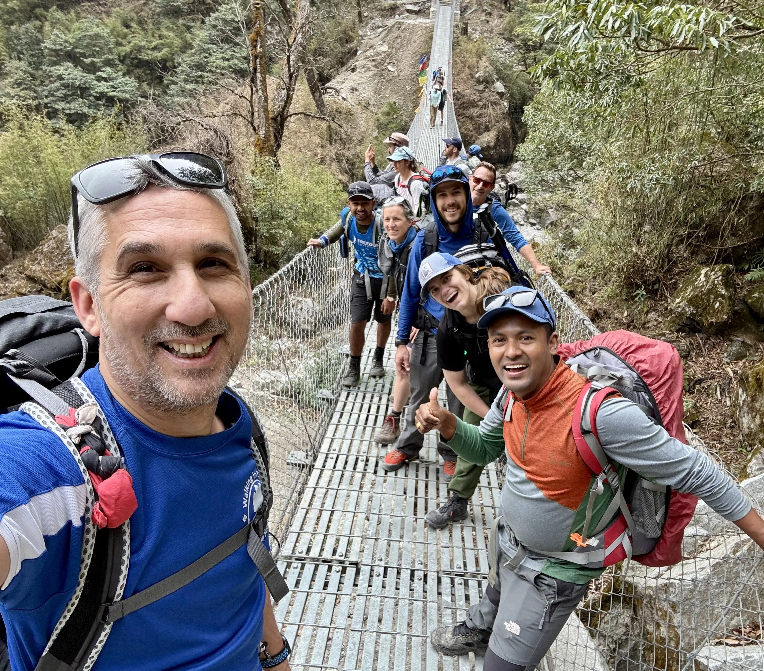
We traverse the river a few times, via suspension bridges…very familiar to me from my EBC trip, and it’s a great feeling to walk over them once more.

We make a brief stop at a small village, for a cold drink and toilet break. Then we’re off once again, now onto road…not road as you’d expect, more of a long, dusty trail. As the occasional truck or jeep passes by, we’re needing to cover our faces a little to protect ourselves from all the dust that gets stirred up. But after a longer than expected day, we make it to our tea house for tonight in Danaque.
Our room isn’t too bad, and we’re right near the outdoor toilet and shower. To my absolute surprise and delight, there is an abundance of hot water!! That was needed. Feeling clean, we all meet up for dinner, and some of us stay up a bit longer to play a card game…UNO, what else!
These moments, in the tea houses, are a great way of getting to know others in your group, and form bonds.
Julianna (bless her) was busy taking care of Rachel. So the rest of us stayed up a while and talked. I spent some time chatting with our friends from the USA…John & Hannah, and Janell and Luke. John & Luke are brothers, although totally different characters. All four of them are really cool, easy to talk to, and most importantly, a lot of fun to hang around with!
Day 6: To Chame
I didn’t manage to get much sleep last night, perhaps 3 or 4 hours! So when it was time to get up I was feeling tired and groggy! Apparently, according to Rich, I still snore!
But breakfast was great…porridge with apple and honey! So delicious! And with the sun already out and clear skies all around, my spirits lifted for what was in store for today’s hike.

We started out on the road, and through the village, but once passed the building works for a new hydro power station (courtesy of China), we turned off the road and up onto a winding track. Very soon we were greeted by a simply stunning view…

…enveloped within the trees, lay a waterfall with a suspension bridge rising above it, and rising above that in the distance, some mountains. Just a surreal view, and a fabulous start to the day.
We crossed a couple of other bridges, and began climbing again, slowly in the heat of the sun, and it was only 9.30am still!
After a brief pause, we entered a forest, which was filled with rhododendron trees, that were beginning to bloom with bright pink and red flowers. Some of the trees rose so high…and the colours of the flowers stood out against the backdrop of the forest and mountains far off in the distance.
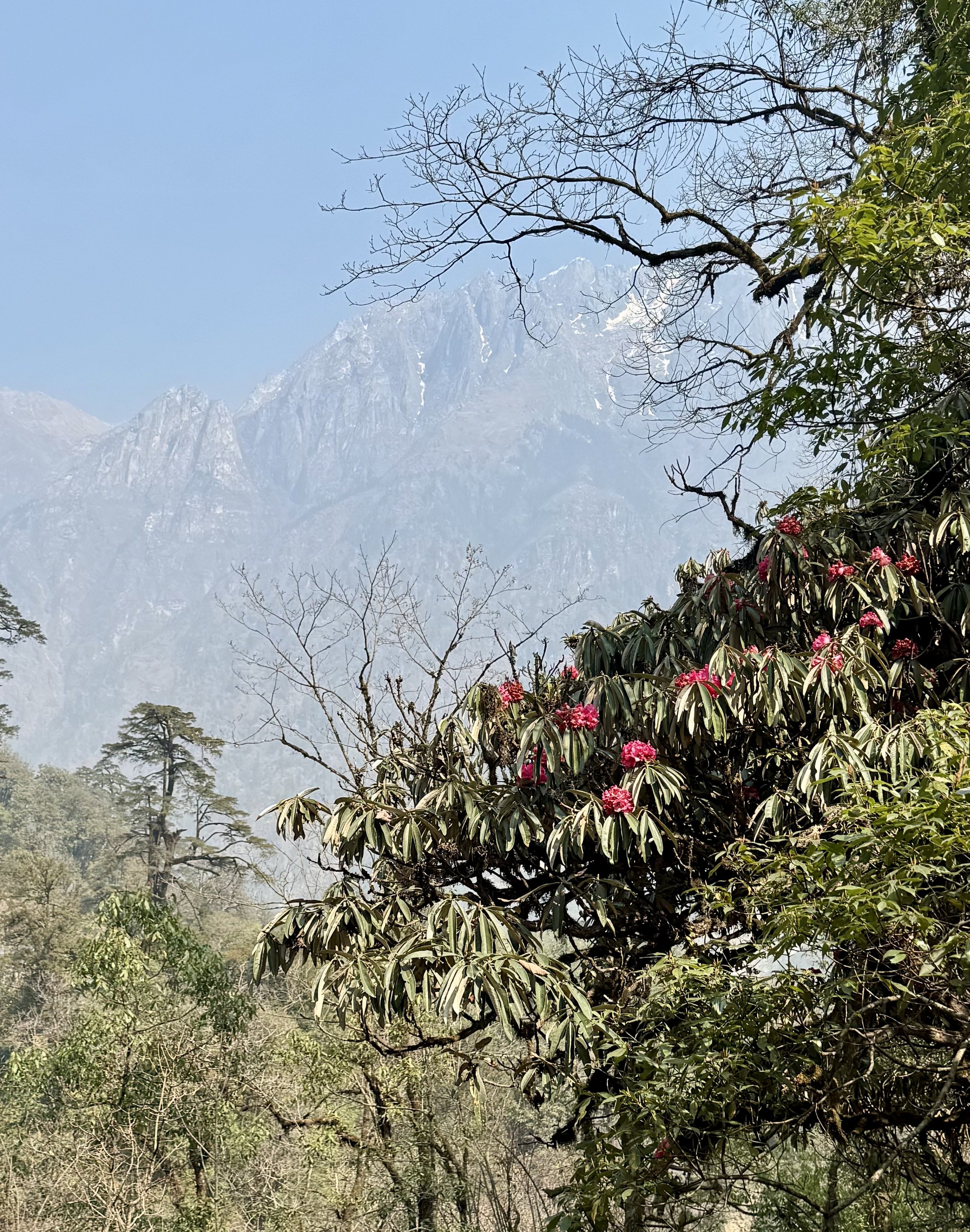
Through the forest we crossed another suspension bridge and were treated by a spectacular view of Manaslu, one of the highest mountains in the world, rising in the distance!

We followed a path with Manaslu ever present, and stopped for a lengthy tea break on a tea house rooftop in Timang, just sitting there as we admired this majestic mountain.
Moving off once more it was a shortish 30 minute walk to our rest stop for lunch. It was hard moving off after a heavy lunch, and our path initially took us steeply downhill, through bush, and forest, crossing another suspension bridge, then passing a small village, before the path rose up once more to Thanchok.
We were now on a flatish dusty roadside trail, which felt a lot easier than what we had been accustomed to during our day so far. As the day wore on, we passed a beautiful Stupa, as we began to near Chame, our destination for this evening.

It had been a long but beautiful day walking in the Himalayas. I just have to pinch myself sometimes to remind myself where I am!

Although there’s plenty on offer in Chame, in terms of places to eat etc…and I had been looking forward to the bakery, and Richard the yak cheese shop, I was just too tired to venture out. Richard however decided to get his hair cut! As you do in the Himalayas!
Sitting here now in the common room, with the yak heater slowly warming my cold bones up, I’m looking forward to my hot dinner followed by an early night…I’m tired, but very happy! Dinner was great…egg fried noodles and Tibetan bread! Lovely! Then one of our Sherpa guides introduced us to a Nepali card game, and we were also joined by the owner of the tea house. It was such a fun night, and just really surreal.
Day 7: Chame to Upper Pissang
I was awake early, after having yet another awful night, with barely any sleep! I think it’s a pattern that I’m afraid I’ll have to endure for the duration of the trek…but hopefully I’m wrong.
But, due to Richard’s insistence to Tika, we were now in separate rooms. So i didn’t have to put up with his constant whining about my apparent snoring!
Before breakfast a few of us stocked up on some supplies from a small shack across the street. Mini Tibetan prayer flags seemed to be the must have souvenir!
After my breakfast of apple porridge - fast becoming my go to, it was time to head off. We had a 6 hour or so hike in front of us. We walked slowly through the streets of Chame, which pretty much had everything you could wish for in a Himalayan village. Shame we couldn’t spend another day here.
But it was a glorious start to the day as we weaved our way out of Chame.


The majority of the morning we followed the river, which was nestled below stark high rising cliffs of pine trees, then winding through high banks of dusty grey and brown stone. It was a beautiful and peaceful walk, and not overly challenging.
I was by now getting to know Max a bit more. Max, at 27, was the youngest in our group. Very laidback, with a cool sense of humour, he’s instantly likeable. He reminds me of a younger Rich (although without the ‘instantly likeable part)! :)
After a couple of hours or so, we reached a small village of Bhratang, where to our surprise was a fairly modern coffee shop come bakery, which specialised in apple produce - from apple donuts, apple crumble, cake, even apple wine! Plus specialist coffee! Man it was good!
We continued along the path overlooking the river to our left, and a rocky cliff face on our right, which was just incredible, and brilliantly capture by Hannah!
We then ascended into the woodland, and then over a short but stunning suspension bridge!

Further along through the woods we walked, until we broke out and headed right, and down into a village where we stopped for lunch. As we sat there, some of us now opting for boiled eggs (a re-occurring theme throughout our trek), the views from our rooftop terrace were awesome!

After lunch we only had a short distance left to reach Upper Pissang. Around 45-60 minutes of hiking. The main thing to note was that the temperature had changed now, and with the wind, fleeces were brought out! But it was a quiet and pleasant end to our hiking for today, as we reached 3,300m at Pissang.
Rich, had again persuaded Tika to arrange for us to have separate bedrooms. I took the opportunity to grab a hot shower! Although, rewind…it wasn’t hot (for me), in fact it was bloody freezing! But I didn’t care. My whole body and head felt full of dust, so despite the freezing water, I was clean.
Before dinner, Rachel, who was feeling just a little better, offered to run a much needed stretch class, in the tea house common room.
Just a quick rewind…remember i said much earlier that Rich had winged it prior to coming on this adventure? Well, he now knew what he was in for! He remarked to me that he had no idea how tough the terrain would be, although he agreed it was truly stunning! All the same, his aching muscles now told him all he needed to know!

Day 8: Upper Pissang to Manang
Wow! What a cold night! Considering the temperature this morning is -8 degrees, god knows how cold it was in our paper thin walled rooms during the night!
Anyway, it’s a beautiful morning, with clear skies, and the sun is working its way up above the tea houses. Good job as we’ve got a beast of a day ahead of us. Around 9hours and 18km of hiking, and with a massively steep incline early on. The one thing keeping mine and the team’s spirits up is the thought that we’d have 2 days recovery at Manang.
For now, i was just admiring the view of Annapurna 11 (7,947m), with the sun glinting off its head, from outside my room! We’d be seeing a lot more of this impressive mountain, with the monkey face peering at you, and other impressive peaks, during our long hike today.

After breakfast we set off, right through the village and up into an easy going track. The track, like most terrain around these parts, weaved up and down, in true Nepali flat style, as it hugged the mountainside.
Like so often during parts of our walk, we’d pass a line of prayer wheels, and as is customary, we’d turn them in a clockwise direction.

Rachel, who was still feeling unwell, took a lower path with Anil, so she’d be able to avoid some of the bigger ascents today. She’d need to get her strength up for what was to come over the coming days.
After only 20 minutes or so we got more views of Annapurna II, as we walked along a stony path for a little while. Then we approached a suspension bridge below us and rising up on the other side was the steep and winding hill we were faced with this morning. This climb we were told, would take us around 90 minutes, and at a reasonable altitude it would really test our breathing and endurance.
Needless to say…it was a real struggle, and it was noticeable how heavy my breathing was. Fortunately we made fairly regular stops to suck in some much needed air in our lungs, and take in some water. The views behind us were just stunning, with the Annapurna range in great view.

This pattern continued for an hour or so. It was tough going, but I knew this was just a dress rehearsal for what we’d have to face in a few days time!
Eventually we made it to Ghyaru 3,670m, where we’d stop for a tea break. It was an awesome spot that gave us panoramic views of Annapurna II, III and IV. Plus other high peaks. They looked so close, and it was hard to believe we were looking at some of the highest peaks in the world! What a treat!

We left Ghyaru and continued along an undulating mountain track, a dusty road that snaked around the mountain edge.
After just 5 minutes or so, Rich realised he’d left his ‘Walking in Circles’ fleece that i had got for him behind at our rest stop. He was about to head back, when he noticed that Luke was wearing it! Apparently Rich had dropped it hours earlier when we were walking up that hill, and he hadn’t even realised!

Practical joke over with, we continued on. Annapurna II was still visible, and eventually we could also retrace almost where we’d started our day, which appeared way down below and to our left. We’d ascended quite far, but we also knew the day would end lower down than we were at present.

At around 1.30pm we made it Ngawal 3,657m where we’d stop for our lunch. I opted for a potato curry and japati bread! We rested for almost an hour, then it was time to head off again. We still had a good 2.5 to 3 hours hiking to get through. The sun was now behind some clouds, and with the wind that had picked up, the temperature felt much cooler as we set off.
Our path was mainly road or stony track, as we walked down into a deep and vast valley, in the direction of Manang. We were now on a long, stony track, that seemed to go on forever, which I guess was due to fatigue, and with the last remnants of sun the temperature was rapidly dropping. So we were all keen to just reach our tea house.

Of course eventually we did, and it felt great! Plus what an amazing tea house! Really comfortable common rooms, much like a ski lodge, and the food choices were great, and much more on offer than anywhere else we’d stayed or would stay.
Rich decided to get some laundry done in a local shop, which was a smart decision! I held onto the belief that I had enough spare clothes to last me. In the evening we gorged ourselves on some of the delicious food on offer. I opted for a pizza and french fries…amazing!
So after a very long day, it’s time to go to bed…separate rooms again for me and Rich obviously! What a day!
Day 9: Acclimatisation Day
I had a much better sleep last night. Fell asleep almost instantly! Despite waking up a few times to go to the loo, I’m feeling much more rested than I’ve felt in a while.
Today we went for our acclimatisation walk - a 300m ascent up a hill round the far side of Manang. Doesn’t sound like a lot, but it’s a 5 hour steep walk there and back, reaching an altitude just under 4,000m! Hence why it takes so long.

En route we passed Gangapurna Lake, which was really pretty. It was a great climb, and felt much easier than the one we did just yesterday. Reaching the lake was incredible, and it offered us some were spectacular panoramic views around the Manang valley.

We continued our ascent, as the narrow path weaved its way higher and higher towards the plateau, with trees adorned with colourful Tibetan prayer flags.

Photo below: Janell and Luke taking in the vista…

We still had a little further to go before we reached the summit of our hike today however. But once there we rested for a short while, before we began to head back down.
However the descent I found much harder, due to the heavy impact on my knees, and I found myself towards the back of the group as I slowly made my way downhill.
Once safely back at our lodgings, we had a free afternoon however, which i think we were all very grateful for!
First I headed straight for the shower, and grabbed the hot water…a precious commodity on the trail! Omg it felt soooo good! I’m clean, and my body felt hot…which it hasn’t done in over a week. The temperature here had dropped really low, especially when the sun disappeared. And it’s only going to get colder still!!
In fact as i was writing this, i looked out of the window to see that it was snowing!
In the evening, we all ate very well, and Uno club had yet another competitive game! All except Julianna, who was now starting to feel sick - she had picked up Rachel’s tummy bug!
As we’d be leaving here tomorrow, things will start to get even tougher, which of course we’ve been expecting.
Day 10: Manang to Sri Kharka
After a fitful sleep, I got myself up and dressed around 6am, even though breakfast wasn’t until 7am.
It was sad to leave our lodgings in Manang as we had been well and truly spoilt, with great rooms, and awesome food! We set off however around 8.30am, in good spirits, as we thread our way up and out of Manang and onto the gentle roadside.
It was another beautiful morning, and the sun was already warming us up, as we walked alongside the Thorang Khola River. The road ascended slowly, and as we left the river lower down, we continued long a pleasant track, passing our first signpost marking the direction of Tilicho Lake.

We reached a suspension bridge, and duly crossed. This led us into a short climb up to a precipice where we took a short break.
We continued along the narrow and pebbly path that hugged the cliff, for about 45 minutes.


Until we made it to Khangsar, the last village in the area. Here we stopped for tea (and boiled eggs for a few of us)! I think we must have stopped for an hour or close to. The sun had been beating down on us, and I was pleased to get moving again.
We had a gentle climb straight after. We continued to follow the dusty road, which climbed steadily. It wasn’t too long before we reached our destination of Sri Kharka, 4,050m.
We immediately ordered some lunch, and relaxed for a while. Rich and i shared a room once more, as Rich gave up his own room for Karen, who had been sharing with Julianna, and obviously wanted to avoid picking up her tummy bug! However, it was a spacious room, even having its own balcony with gorgeous views. I took the chance to take a moment to put my feet up.

Tika, our head Sherpa guide, said we had an optional acclimatisation walk in the afternoon. It was a great opportunity to get some more elevation and training for the higher altitudes and lower oxygen levels. Rich and Max decided not to go, as they needed some rest.
We climbed to a height of around 4,250m, via some really gorse and prickly shrubs. Julianna despite her tummy bug, braved the climb, promptly threw up at the top of our acclimatisation walk…poor her!

The remainder of the afternoon and evening went by very quickly, and it was noticeable how busy the tea house had got. In these remote areas, there aren’t too many places to stay, and this would be a popular outpost for people heading via Tilicho Lake, or back onto the Annapurna Circuit.
Day 11: Tilicho Base Camp
“One does not simply enter Tilicho Base Camp”
Any fans of Lord of the Rings will recognise the name Mordor…a bleak landscape home to the Dark Lord Sauron! Well, that’s how it felt today making the crossing from Sri Kharka to Tilicho Base Camp!
But first…me and Rich woke up early, and it was very cold in our room. It was hard getting out of our sleeping bags! But I opened the curtain and the sun was beginning to rise, and there was a low hanging mist below us in the valley…it looked beautiful!

Not a long hike scheduled for today, which I was grateful for, but it did prove to be challenging all the same, as you would have gathered already.
The trail started off ok, and was really easy going. The sun was out and it felt good to feel the warmth once more in my bones. We crossed a suspension bridge and climbed up a steep path.

We reached our tea stop in good time. So far so good.
It was the second half of our trek where the trail really changed and actually got a bit hairy in places.
The path became very narrow, and we passed many sections with warning signs of potential landslides! It was here where the “Lord of the Rings” landscape became the topic of conversation between Tom and i. It felt very strange and I half expected to see Orcs ascend upon us at any minute!
Joking aside, I was extremely nervous at some of the path we had to cross…very narrow tracks, with high slopes filled with loose stones which looked like they could tumble like dominoes at any moment. So you weren’t allowed to stop during those sections. What was also going through my mind was that we’d have to cross this route in reverse tomorrow afternoon!
However, despite this, the landscape and rock formations were simply stunning!

Above photo courstesy of Hannah


Eventually the danger zone was over, and we could see Tilicho Base Camp in the distance.
An interesting morning’s hike…with incredible landscapes and geological features. A few of us passed up the afternoon’s acclimatisation walk to relax. I felt it was better for me to sit there and write up my notes. Plus tomorrow we would have our most challenging hike of the trip so far to get done! To Tilicho Lake.
In the evening, as usual the uno club (minus Julianna, who was still sick) sat together after dinner for a few highly competitive games, particularly between Rachel and Max!
Everyone went to bed early, fully dressed in sleeping bags, ready for our 4am start to Tilicho Lake!
Day 12: Tilicho Lake
Today was by far the hardest and longest trekking day so far…but we knew it would be, as today we’d be hiking up to Tilicho Lake (4,919m), and then back down, to Tilicho Base Camp and then further down returning to Sri Kharka.
Our alarms were set for 3.30am!! We were to meet for breakfast at 4am.
Rich and I had slept in our hiking clothes so we’d be ready. It was cold, I mean really cold outside…around -10 degrees. So everyone had loads of layers on.
Julianna, wasn’t able to join us, and would take the opportunity to rest and recover…bearing in mind we still had Thorong La Pass to come!
Torches on, we set off.
Photo courtesy of Hannah

We had around 800m of altitude to gain, in order to reach Tilicho Lake.
Everyone I suspect was getting themselves into a rhythm of walking, as we slowly climbed, whilst we weaved up and out of Tilicho Base Camp. Rich had eaten something not quite right the previous evening, and It wasn’t long before he had to make an urgent stop…in the dark, and extremely cold night air!!
Continuing on up the hill, that first hour felt a bit surreal, as you could see many torches dotted around the landscape, all with one objective. But soon after, dawn was starting to break and there was a feint glow of the sun far behind us as it lit up the immense Himalayan peaks. The views were incredible!


The morning grew warmer and layers were pulled off, as we continued to climb slowly higher and higher. It was hard going, as the effects of the higher altitude can really sap the air out of your lungs.
Higher still, and we came to a resting point with just with a couple of squat toilets…another emergency call for Rich…and he later joked that he’d start a “Go Fund Me” campaign for a toilet to be erected in his name! :)
Again we climbed, in the heat, up and around seemingly endless twisting bends. We came to a plateau with a small pond…no, not Tilicho Lake, and it was noticeable that the temperature had now dropped. So extra layers were added for the final push.
The final 30 minutes the path flattened out, and we were walking in between pockets of ice and snow. Just a little further…
After approximately 4 hours of climbing we eventually reached Tilicho Lake (4,919m)!! Whoop!!

In my mind I had thought the lake would be a kind of turquoise blue, similar to what I’d seen when I went to GOKYO Lakes, and also from photos on Google. However the entire lake was frozen…it still looked spectacular it had to be said.
Either way we were all really excited to have made it there. We spent around 30 minutes up there, as we took plenty of photos, and took on board some much needed energy via snacks and drinks.

Then it was time to head back down. And this is where things got a little tricky for me. My knees began to throb, and I slowly began to drift towards the back of the group. As steep as the ascent had been, obviously the descent was punishing, and I was in pain! So I decided to just go slow, and do it at my own pace. One way or another I’d get back down.

I was concerned about the afternoon and then beyond that, but everyone gets moments of doubt at some point during these type of expeditions. Half way down Karen, who is also a Doctor, gave me 3 ibuprofen and 3 paracetamol. I continued on. Still in great pain I eventually reached Tilicho Base Camp, and duly collapsed on a bench, exhausted. Everyone else had already got there, and Rich, seeing I was in need of a sugary drink, passed me his coke! Cheers mate!
We had plenty of time to recover, get changed into lighter gear, and have lunch before we’d have to set off again on our journey down to Sri Kharka. The good news was that by now the medicine Karen had given me had well and truly kicked in! I didn’t feel any pain as we set off once more. We retraced our steps from yesterday, and it was about a 3 1/2 hour hike in total. We made it back to Sri Kharka approximately 4.30pm.
It had been a brutal day. But wow…what an incredible experience!!
Day 13: The trail to Yak Kharka
By all intents and purposes today’s hike should have been pretty easy, especially compared to yesterday’s mammoth one! To be fair, it was, for most of the group. For me however I was still struggling somewhat with fatigue and those pesky downhill descents!
For the first time, the sky today wasn’t as clear as every other day. We’ve been incredibly lucky so far, so we were bound to get a change in the weather! So setting off, we didn’t get those amazing views we’d been accustomed to.
We had been told that the walk would be reasonably easy, with some modest climbs, and some steep descents. So I prepared by taking painkillers before we set off. However, although I wasn’t in pain with my knees as such, I just couldn’t get them working, especially when faced with some really hard downhill sections. So instead of fighting it, I decided to take it at my own pace, and if that meant being at the back of the group so be it. And at the back of the group I was, for most part. Not too far behind, but I wasn’t prepared to risk damaging my body by walking faster, especially given what’s to come!
The morning clouds eventually cleared, and sun came out, as we passed some lovely sections, including the Old Khangasar Village. Then shortly afterwards, a whole mountainside it seemed of juniper bushes!

There followed some steep downhill paths, that again took me a little longer to navigate, and i was grateful when i finally reached our tea stop at the far end of a suspension bridge.
The path after our stop was thankfully much easier, as we made our way towards Yak Kharka.

Day 14: Thorang Phedi Base Camp (4,450m)
Today was a relatively gentle walk in comparison to other days we’ve had during our adventure. However we would be gaining approx 400m - 500m of altitude during the walk, finishing at Thorang Phedi Base Camp at 4,450m. But not too much to report really.

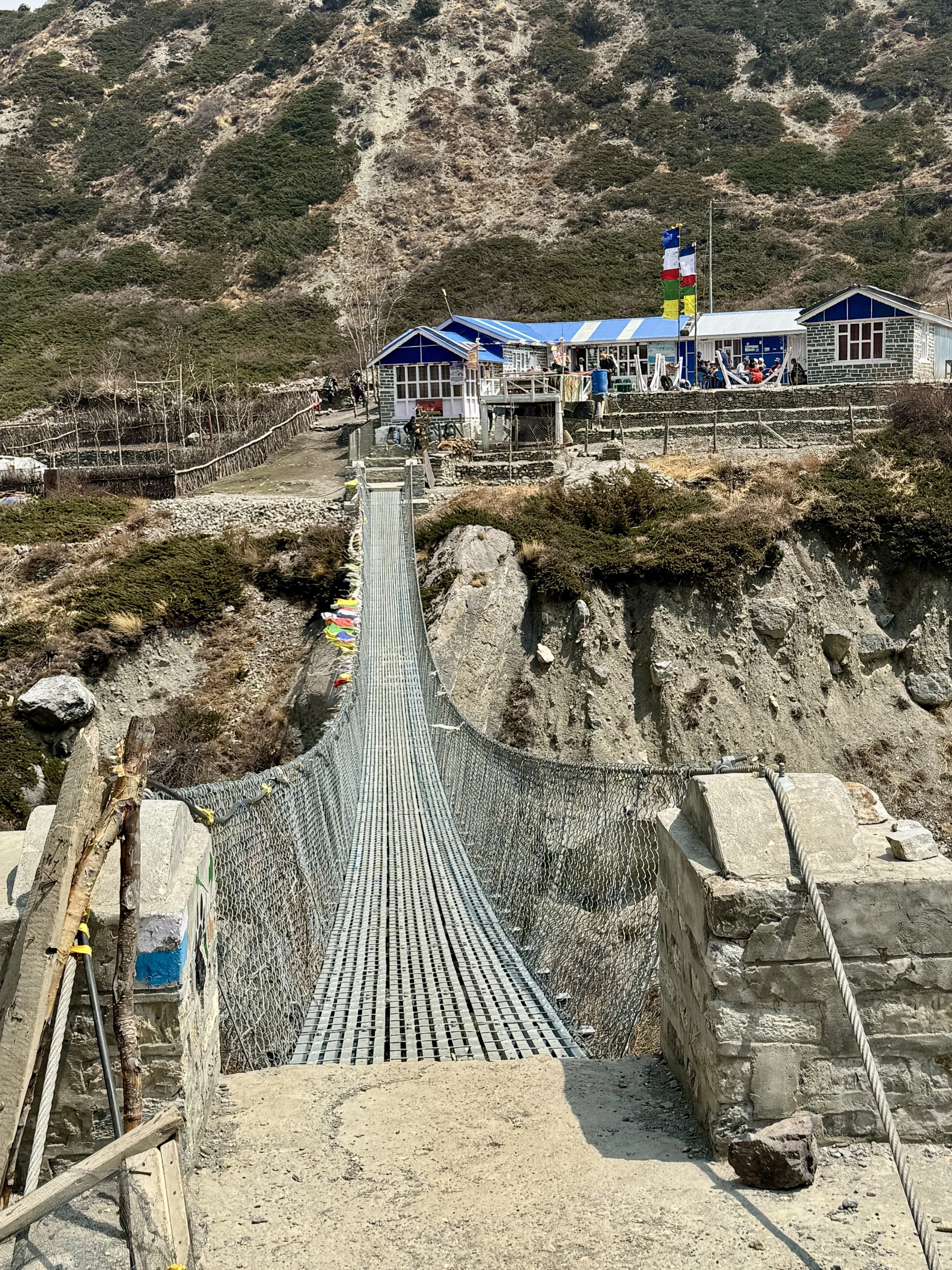
Aside from loads of yaks we saw en route, which was a lovely treat, the only real challenge was as we approached Base Camp, a massive 350m long suspension bridge! It was huge! And it really caught me out in terms of taking my breath away by the end of crossing it. But at least we had made it to our final stop before the Big One tomorrow!

What we all noticed with some trepidation was the beginnings of our route up the mountain tomorrow. A series of never ending, steep winding twists and turns that spiralled up towards a crest. Beyond that, who knew what was in store?
Entering base camp we all gathered in a far corner, and did our best to try and relax. Richard, was in some discomfort with his back. So our resident physio Rachel dug her hands and elbows into his back to try and relieve his pain. I think it must have worked as he was soon back to being his usual slightly annoying self (sorry mate)!
I also think Rachel enjoyed herself too!

During the evening, as we were preparing for the big day, the power to the tea house went out! So for a while we all sat in relative darkness until a back up generator was turned on.

Then something else happened…it began to snow…and quite heavily! At this point we didn’t have any real idea just how much this would impact our big hike tomorrow! For now we all just went to bed and tried as best as possible to get some much needed rest…before our early breakfast at 4am!
Before getting into our sleeping bags, I think most got dressed into some of the clothes we’d be wearing the following morning…firstly to save some time, but also as it was damned cold in our tiny, paper thin walled rooms! I can’t say I got much sleep however.
During the night I needed the toilet, and after putting on my jacket and head torch, I gingerly stepped outside. It was still snowing quite heavily, and it had begun to settle in camp…I felt a little nervous about what the early morning would bring!
The good news was that Julianna had now made a recovery, and would be able to make the hike up the mountain.
Day 15: Thorang La Pass 5,416m
This is it…the BIG ONE!!
3.30am and I’m awake after only a few short hours of restless sleep. After getting the rest of my clothes on and repacking some of my gear, I headed outside in the darkness, towards the tea house common room.
It was still snowing, and it had covered the entire landscape!!
Entering, the common room it was barely dimly lit, as the power was obviously still running low in camp. Our group huddled in our corner as we debated what outer layers would be best to wear given the weather. Most opted for gortex waterproof jackets, instead of the warmer down jacket option, to protect against the wetness of the snow and no doubt wind that would batter us on the higher open mountain slopes.
After a light breakfast, Tika gathered us for our team talk in order to prepare us for what was to come. He also did his usual pre-check on each of us to make sure we were all ok.
Throughout the entire trek, Tika and his team regularly measured our oxygen saturation levels, both in the mornings and evenings. A healthy SpO2 level in most adults is between 95% and 100%. If it starts dipping much below 90% then that could indicate a medical problem.
Fortunately i was still registering 93% - which isn’t too bad at high altitude, and was a relief!
4.20am we filed outside, and after a cry of “Jam-Jam” we set off in the cold, snowy weather.
After climbing a few short steps we soon hit the dreaded twists and turns of the track we had seen only the day before. Now however our path was hidden through deep layers of snow on the ground. It was impossible to see too far ahead and how far each step was taking us.

That first hour or so we all followed in single file, as we slowly ascended the mountain, lost in our own thoughts and concentration to just keep walking! In some way that, and the darkness, may have helped us, as it only made us concentrate even harder on just putting one foot in front of the other.

Every 15-20 minutes we’d take a short break, to take in some water and try and get some much needed oxygen back into our panting lungs! At some point, finally we had got past those twisting tracks and we were nearing the crest of a ridge. Night was slowly beginning to pass and there was now the beginnings of some feint dawn light. We could now start to get some sort of bearing where we were heading.
15 minutes later and we reached Thorong High Camp at 4,800m. A few of the group were battling against upset stomachs or the cold, so it was time for a short break. It doesn’t take long before your body temperature begins to drop rapidly however, so I was grateful when we were back walking once more.

Our path was much more open now as we continued our ascent slowly up the mountain pass.

For the next hour we trudged, until we reached a bridge. After crossing, the path narrowed quite considerably, and seemed to drop away to our right. It was really slippery and it took a lot of effort not to place a wrong foot, as doing so could have been lethal!
Once round the corner, we were told to put on our spikes over our boots, which seemed to be the much safer option!
On we went, as the pass weaved higher across a wide open snow covered expanse. Over the next crest we were told would be a small hut, where if we were lucky, would be open, and we’d be able to get a cup of hot chocolate! We had been craving this, and when we did finally arrive at the hut, indeed it was open and we all huddled inside, grateful to get some rest and warmth from the outside.
It had been so cold, that ice had formed on my head torch and was drooping down giving the appearance of a mini stalactite!

Cups of steaming hot chocolate or tea were rapidly brought round, and we delighted in the warmth and sugary taste that our drinks gave us! But like all good things, at some point you have to let them go, and it was time to crack on once more.
So on we went…for an hour, and another. Even though I could check our altitude via an app on my phone, it was difficult to really know how much further the peak of the pass lay. The path wasn’t so steep anymore, but on and on it went. Eventually, in the distance, we could make out the glimmer of some colourful prayer flags…and at that point we knew…
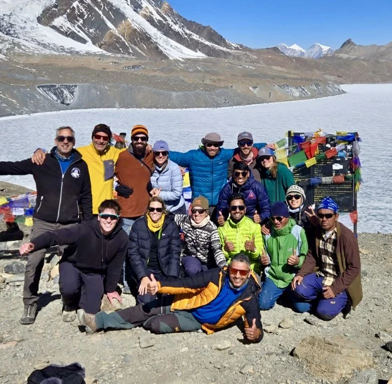
At around 9.15am on 10th April 2025 we made it to Thorang La Pass, 5,416m!
Yes!!! We did it!!!

Emotions came flooding out, along with big hugs and high fives! Our long journey, had taken a great deal of hard effort and energy to get here…and here we were…seemingly on top of the world! Well, the highest navigable pass in the world at least…and we were rightly proud to be standing here.
We all took turns in having our photos taken, including a great group shot of all of us!

We rested, ate snacks, and there were many laughing faces, while we basked in the cool sunshine that had greeted us when we arrived. But, getting to this point was only half our journey for today…we had the small matter of a long descent to reach Muktinath…approximately a staggering 1,700m descent! This part I wasn’t looking forward to, due to my knees which had been getting worse with pain over the course of our trek.
So I decided to just walk at my own pace. One of our Sherpa guides, Anil, immediately offered to carry my rucksack, which although I tried to refuse, he warmly insisted…I didn’t argue too long! Despite now not having to carry a heavy load on my back, the steepness of the downhill terrain began to take its toll, and I found myself drifting towards the back of the pack. No problem, just keep walking, slowly and steadily.

At some point a bit further down, we came across a contingent of Chinese hikers we’d passed several times along our trek over the past couple of weeks. They were huddled over one of their group who was clearly suffering, with what appeared to be altitude sickness, and their guide didn’t have a clue what to do! So Tika, stepped in and advised they get him down the mountain as quick as possible, and arranged for Anil to walk with them. We later found out this guy was thankfully ok, and had a heart pre condition.
After a couple of hours we made it to our lunch stop in a small village. I was exhausted, cold, and hungry! I wasn’t alone! We rested for some time, and tried to restore our energy for the final push towards Muktinath, which was still a couple of hours walk away.

Down and down we went, until eventually we came off the mountainside and onto a road leading into Muktinath. I felt incredibly relieved to be on smoother ground, and knowing we were close to the end of our long arduous journey today.
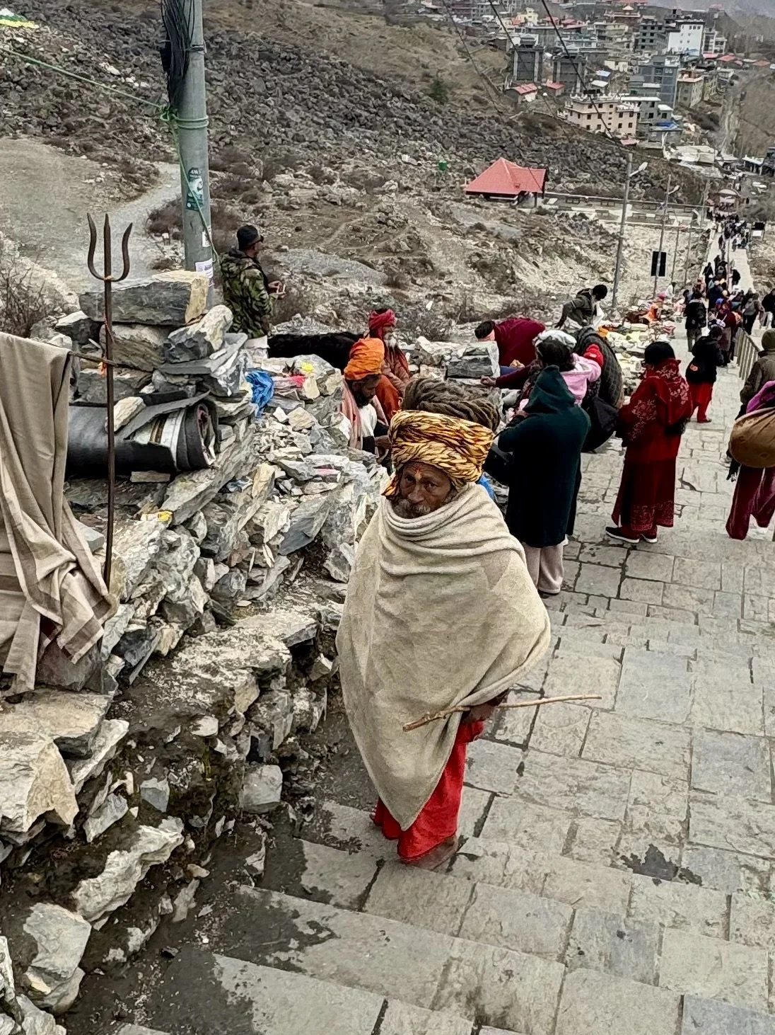
Muktinath is a holy and spiritual town. As the only Divya Desam outside of India, it is flocked by thousands of people making pilgrimages to visit the Vishnu temple. It was an eye opener for sure, and a stark contrast to every other place we had visited or passed through.

Eventually, after a slow walk through the temple, we headed down some steep steps and made our way to our guest house for the night. Our reward…a hot shower in our rooms! Oh yes! And back in the common room, we treated ourselves to a few well deserved beers!
We had made it!! Almost 12 hours of trekking up and down the Thorang La Pass, but we had made it!!
Day 16: Muktinath to Jomsom
Today we set off knowing that this would be our final day of trekking the Annapurna Circuit. An 18km, but gentle descent to Jomsom.
So as we began to walk in the early morning sun through the dusty streets of the ancient town of Muktinath, there was a mix of joy and excitement in our hearts at knowing after today we’d finally get to relax after our long journey, with a tinge of sadness that we’d be leaving the tranquility and beauty of the Himalayan mountains behind us for the final time.

Once we had made our way through the ramshackle streets, we walked down a dusty path and then onto a quiet village road. Round a few bends and then we exited the road for a short descent through some idyllic countryside tracks. The walk was now gentle and felt just like an everyday countryside hike except for the backdrop of the mountains and hills still around us, reminding us of where we were!

We came back onto the road again, as the path expanded into a wide open vista, with incredible views of the lower hills and rocky peaks below us stretching for miles. The wind had now picked up on this path however which made the air swirl in our faces, forcing us to wear buffs or other forms of protection against the dust.


We were now following a narrow rocky track above the Kali Gandaki river to our right, and as we began to approach a small village for our tea or lunch stop, we noticed a long line of soldiers walking far below us along the road in formation. These soldiers were Nepali Gurkas, each armed with long rifles. Keen to see them more up close, we headed down towards the roadside, and for a short while we walked almost alongside them, as we approached our rest stop.
This small village, if you could call it that, also happened to be where the soldiers gathered and rested temporarily. We decided to stay and have some food, albeit it was a long time until anything resembling food finally arrived! Egg fried rice seemed to be the only food actually available on the menu, so that was our lunch!
It was a long time before we finally set off again, and this section of our final journey would almost all be on a main road leading us towards our final destination. The road was fairly quiet however, albeit windy and dusty in places.

But for the next 2 hours we walked and talked, as slowly we came ever closer to Jomsom. We could actually see Jomsom from a long way afar, but it was almost an hour before we reached the city and then, finally, our guest house.
Our Annapurna Circuit Trek was complete!
Sitting there on long sofas we all ordered a cold beer and raised our glasses to each other. We had done it! Annapurna Circuit Trek - nailed!!
Most of us now were very keen to get out of our dirty and extremely smelly clothes and take advantage of a hot shower in our rooms. It felt amazing to feel the hot water slowly cleanse my body, and even better to exchange my hiking clothes for something more comfortable and clean that I had been saving for just this occasion!
Before we sat down for dinner, Rich and I collected money from everyone so we could tip all our guides and porters. These guides and porters were now our friends, our family. For 2-3 weeks they had led us, fed us, and cared for us like we were their children. We each knew we could never have done this without them, and their love and support throughout our journey. It was our turn to repay some of the generosity and kindness they had shown us.
Juliana had also bought some cards, which we all signed and wrote small messages on. For the first and final time, everyone, including all our guides and porters sat at the table to eat together. For the past 2-3 weeks they had served us when we sat down to eat and drink. Now It was our turn to serve them.
After dinner, Tika gave a small talk, and then I presented him with our collection of tips and the cards we had written for each of our guides. Then one by one everyone stood up to say something. It was so moving, and there was quite a lot of emotion in our voices.
Tika had arranged for a loud speaker to be brought into the room and for the next hour or so, we all danced and sang together. It was a wonderful celebration and fitting end to our journey together.
Except for Tika, tomorrow we would be saying goodbye to our guides and porters, our new friends.

Day 17 to Day 21
Day 17: Jomsom to Pokhara
5.30am as we all gather in the hotel dining room. After a quick cup of coffee, our guides present us each with a white, traditional Nepali scarf, which is a lovely touch.
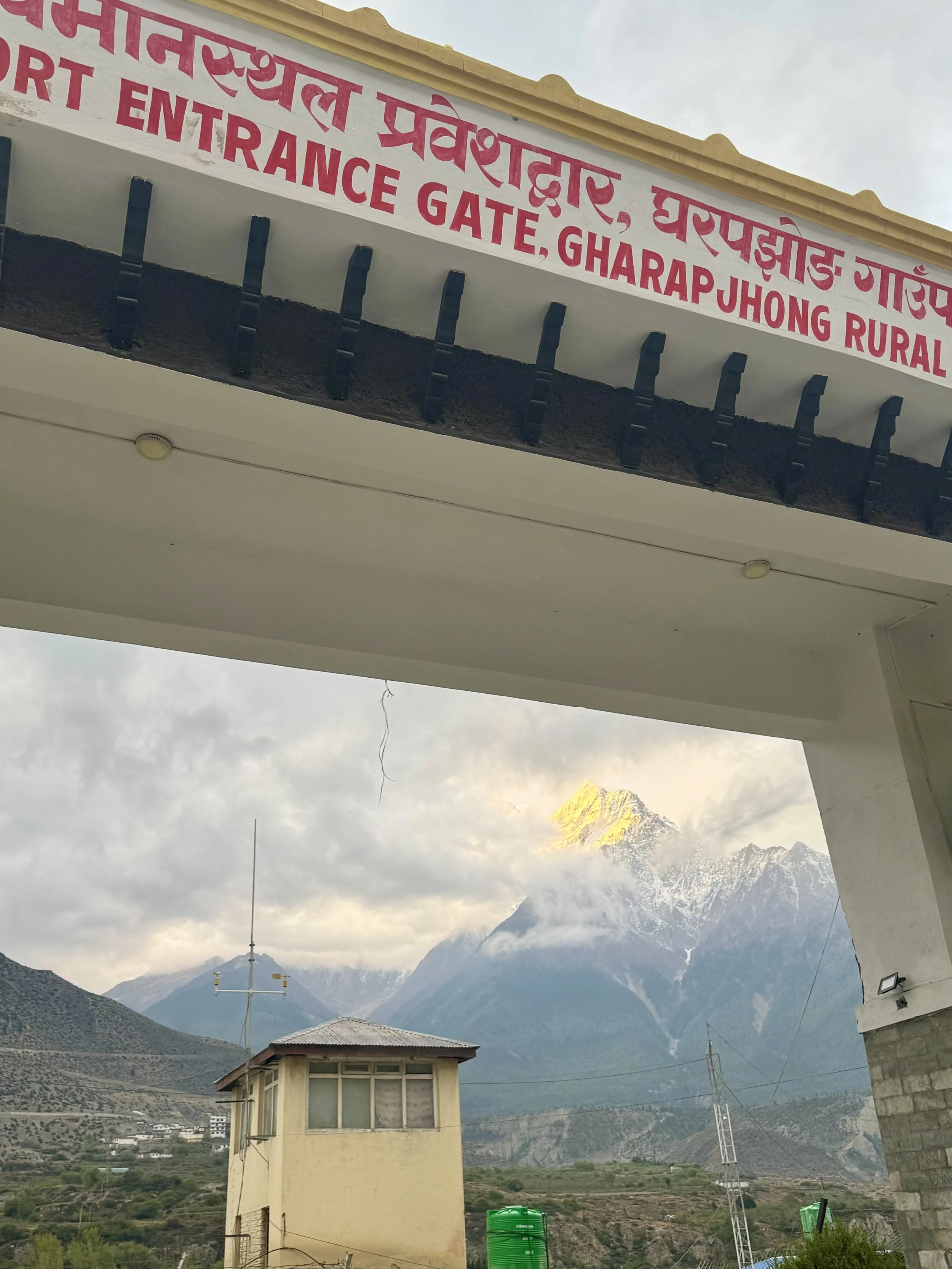
Then it’s a short walk to Jomsom airport…I say airport, it’s an outbuilding with a tiny lounge area and a single airstrip. As we passed through the entrance gate, amongst the clouds, the sun was glinting off the top of a far distant peak.
Knowing from my previous visit to Nepal that actually getting the short flight out of the Himalayas is 50/50 at best, due to the changeable weather conditions, I settled myself down for what I expected to be a long waiting game.
After our bags were weighed and tagged, we all sat around as we patiently waited for any news of our flight.
So far nothing had taken off from Pokhara that morning. We would be the first flight out of Jomsom, should a plane actually arrive, but still no signs of any plane coming soon.

One hour passed, then two. Still no sign. A few of us ventured out of the airport to grab some coffee, and when we got back, still no word.
Eventually, an announcement came that all flights were cancelled!
Tika though had already arranged for a couple of jeeps to transport us to Jomsom by road. We had no choice but accept that we’d now have a long 7-8 hour drive instead of a short 30 minute flight! So the UNO Club climbed into one of the jeeps and the rest of our group into the other. Our driver said we could connect our phones to play some music if we wished…oh yeah!! We were now officially the Party Bus!! A stream of 80’s classics, some 90’s, and a few randoms thrown into the mix, kept us going throughout the entire journey!
Poor driver! But what a ride it was! The roads, yes were bendy, full of holes, and right on the edge of the mountainside. But the views were just jaw dropping! The time seemed to fly by. There was one section in particular that literally took our breath away…the Kali Gandaki Valley! The deepest canyon on earth!

Wow! It was an awesome sight as we drove round and through this stretch of Himalayan landscape. Huge cliffs rising higher than we could see, with the river flowing way down below. Just stunning!
We did make one or two stops along the way, but it was our last rest stop that was especially impressive. The Gandaki Golden Bridge. Spanning 567m and at a height of 122m above the Gandaki river, it was truly spectacular!

Back in the jeep and it was a couple more hours until we could finally see Phewa lake, the largest of 8 lakes surrounding the magnificent city of Pokhara.
Pokhara, Nepal’s 2nd largest city after Kathmandu, is the capital of the Gandaki province. With approximately 600,000 inhabitants, it is a truly metropolitan city, vibrant, bustling, but adorned with ancient lakes, waterfalls and gorges, and of course the backdrop of the Himalayan mountains.
Most people visit Pokhara either before or after the Annapurna Circuit or Sanctuary Trek. Our arrival also happened to fall a couple of days before the Nepali New Year 2082. So the city was busy with people flocking for the upcoming celebrations.

We checked into our hotel….an actual proper hotel, complete with all the mod cons you’d expect from any modern city hotel…something we were truly grateful for after having spent the last few weeks in small Himalayan tea houses!
We spent the remainder of the afternoon either walking around the streets, doing some souvenir shopping, or just sitting by the lake.
I ventured down to the lake with Karen and Tom, and we sat there for a long while, over a drink, or two, and some snacks.
The lake now was beginning to be silhouetted by the sinking sun of late afternoon, and it was a totally serene setting. The perfect way to just sit back, have a drink and relax.


Tonight was our last night all together and with Tika. He had arranged a table at one of the lakeside restaurants, which was the perfect setting for our final meal and celebrations.

Needless to say we all had lots to eat and drink…including several shots of god knows what! A brilliant night and conclusion to our journey together.

Day 18: Pokhara to Kathmandu
After one of the better night’s sleep I’d had in a while, and a decent breakfast, Rich and I, together with Julianna, went out into Pokhara looking for some gifts and souvenirs. Even at 8am it was already a hot morning as we walked up and down the streets.

Gifts and souvenirs bought, we walked down to the lake. It felt great to just stroll around whilst we soaked up the morning sun. The lake looked totally serene.

Today was Nepali New Year’s Eve, and already there was the hum of music and drum beats echoing in the streets. Rich, Julianna and I walked casually through the streets, taking it all in, popping into the occasional shop for more gifts.
As Rich and I were due to take a short flight to Kathmandu at 1pm, (instead of the long 8+ hour drive that Karen and Tom were doing), we went back to our hotel, got our bags together and waited for Tika to collect us. He arrived soon enough, and we were driven to Pokhara airport.
It was here that we said our final goodbyes to Tika, our lead guide and friend.
Thank you Tika…you were amazing!!
We didn’t have to wait too long to board our plane, and after a smooth flight we arrived back in Kathmandu 30 minutes or so later.

Exiting the plane we noticed that the skies were darkening in the distance…it made us wonder how others in our group would fare when they had their flight a little later today…more on that in a moment!
We were collected by baggage claim, and driven to our hotel in Kathmandu. The traffic in the city is always insane, but today it was just ridiculous! It seemed that thousands of people had descended upon Kathmandu, no doubt in preparation for the New Year celebrations.
When we arrived at our hotel, we found out that Rachel, Julianna and Max, who had been on that later flight, had had a nightmare! They did indeed get stuck right in the middle of the incoming rain during their flight, which sounded terrifying! The flight was then turned around and went back to Pokhara!! So they only had one remaining option to get to Kathmandu…take the long Jeep journey! We all felt for them, as this would take at least another 8 hours!!
It was now raining in Kathmandu. But despite the rain, Rich and I spent some of the remaining afternoon walking around the shops near our hotel, before meeting up with Karen and Tom, who had taken the much earlier, long jeep drive from Pokhara instead of the flight.
Although tired after a long drive, the four of us headed out in the evening to find somewhere for dinner. Rich and I just wanted good old western style cuisine, and wanted to go to the Hard Rock, which the others didn’t fancy, so we went in our different directions. Man it felt great to say goodbye to the vegetarian diet I’d been on for the last 3 weeks, and tuck into a huge burger, and chicken wings!! Plus a couple of well deserved beers!!

Day 19: Kathmandu
As it was our last full day in Kathmandu, there were a number of places Rich and I wanted to visit. On our list - Durbar Square, the Monkey Temple, and the Garden of Dreams.
As we were situated in the Thamel District, the beating heart of Kathmandu, all these sites were right on our doorstep. Also being New Year’s Day in Nepal, the city was heaving when Rich and I left our hotel and made our way through the tight backstreets filled with their tourist shops and market sellers.
It’s only a short walk to Durbar Square, but being very early in the morning, hundreds of people were either making their way in the same direction to Durbar Square, or returning having already made their pilgrimage to this historic and culturally significant site.


The atmosphere was intoxicating as we entered the square, with thousands of devoted Hindu worshippers were gathered to pay their respects in and around the various temples. We bought entry tickets including the museum, and whilst we waited for that to open, we decided to watch the world go by from a rooftop cafe close to the square.
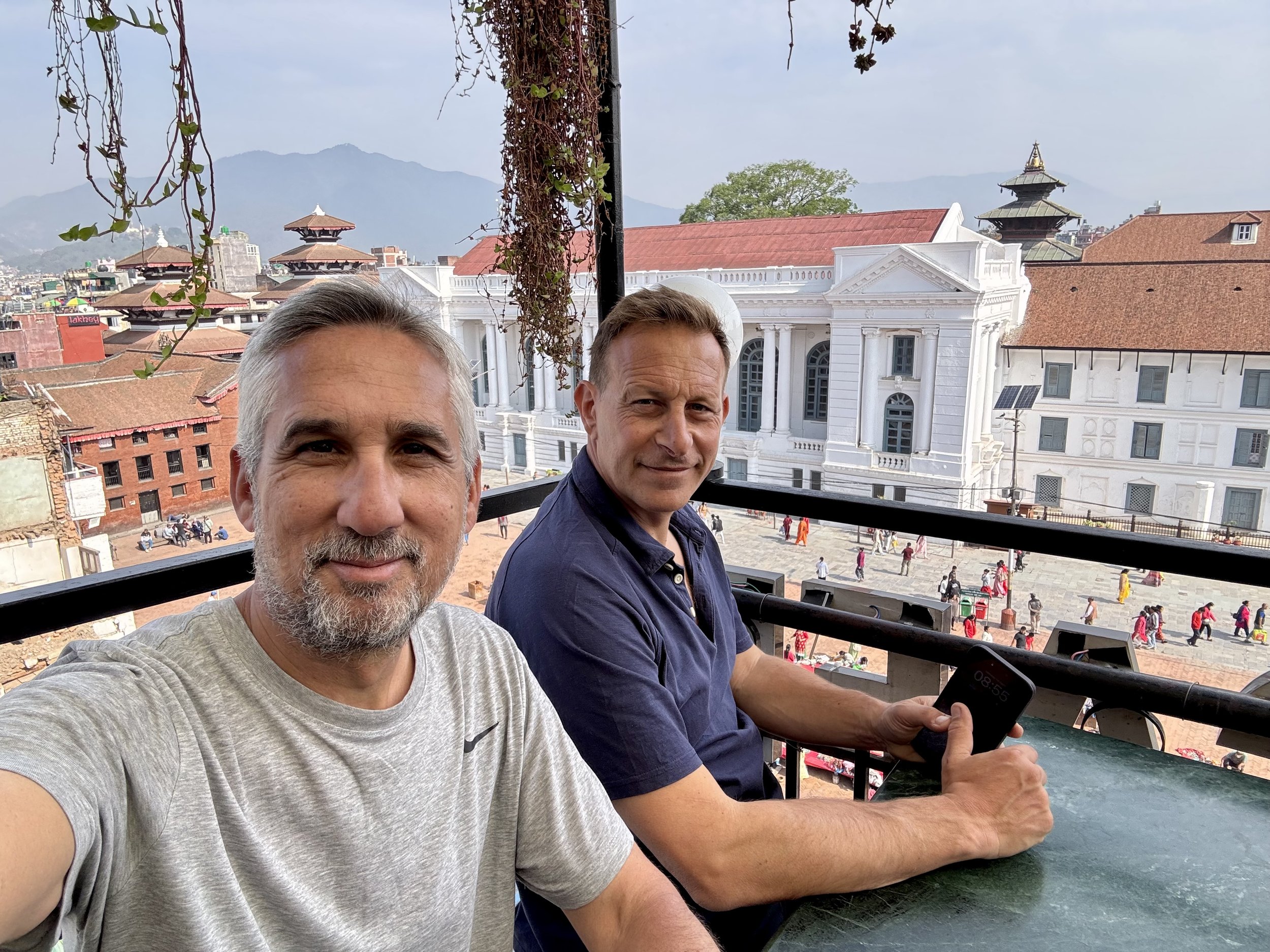
The museum itself wasn’t spectacular by any means, although it still was an interesting place to walk through. My only regret was that we didn’t go to visit the Royal Kumari of Kathmandu, Trishna Shakya, a living goddess, and only 5 years old!
From Durbar Square we then made our way to the Monkey Temple, which although was only a mile or so away, we decided to take a taxi due to the large crowds of people.

The Temple is situated high atop a series of 365 steep steps, that are adorned with Tibetan prayer flags. It’s also one of the highest points in Kathmandu and offers expansive views across the city. It was an extremely hot day as we slowly made our way up the steps, as we began to pass a number of monkeys who were busy trying to find some food. From the top the view was incredible!
The Monkey Temple, or Swayambhu Mahachaitya, its original name, is a religious complex, and one of the most sacred Buddhist pilgrimage sites. The central Stupa is one the oldest of its kind in Nepal and has numerous shrines and monasteries on its premises.

It was extremely busy, with throngs of tourists and pilgrims, and of course many monkeys all scrapping to pick up any food that had dropped to the ground, or if they were smart enough, take straight out of people’s hands!

Once we had spent some time walking around taking it all in, we decided to leave, and we made our way back down the 365 steps, and got into a taxi.
Next stop, the Garden of Dreams. The perfect place to sit and unwind from our morning’s adventures. It was approaching lunchtime as we entered the garden, and already there were quite a few people milling about. But we managed to find a nice bench in a quiet spot, so we could just sit back and watch the world go by.


Satisfied and now relaxed, we left the Garden of Dreams and made the short walk back to our hotel. We met up with Julianna and Rachel, and went out for some lunch close to our hotel. It was great to catch up with them, as both were leaving Kathmandu today, along with Max, and so would end the UNO club! It was really hard saying our goodbyes to them back at the hotel. We had formed such a great bond during our entire trip.
I especially felt for Rachel, who was flying straight from Kathmandu to Bali for a couple of weeks R+R (yeah…sucks, right?!)
Tom by now had also departed. However there were still a number of the remaining group - John and Hannah, Luke and Janell, Karen, Rich and myself. So that evening we all went out for dinner for the final time. Hannah had found a French creperie not far from our hotel.
Rich and I ordered the same meal - a goats cheese salad, which was delicious! It was a quiet but fun way of spending our last night together with our new friends.
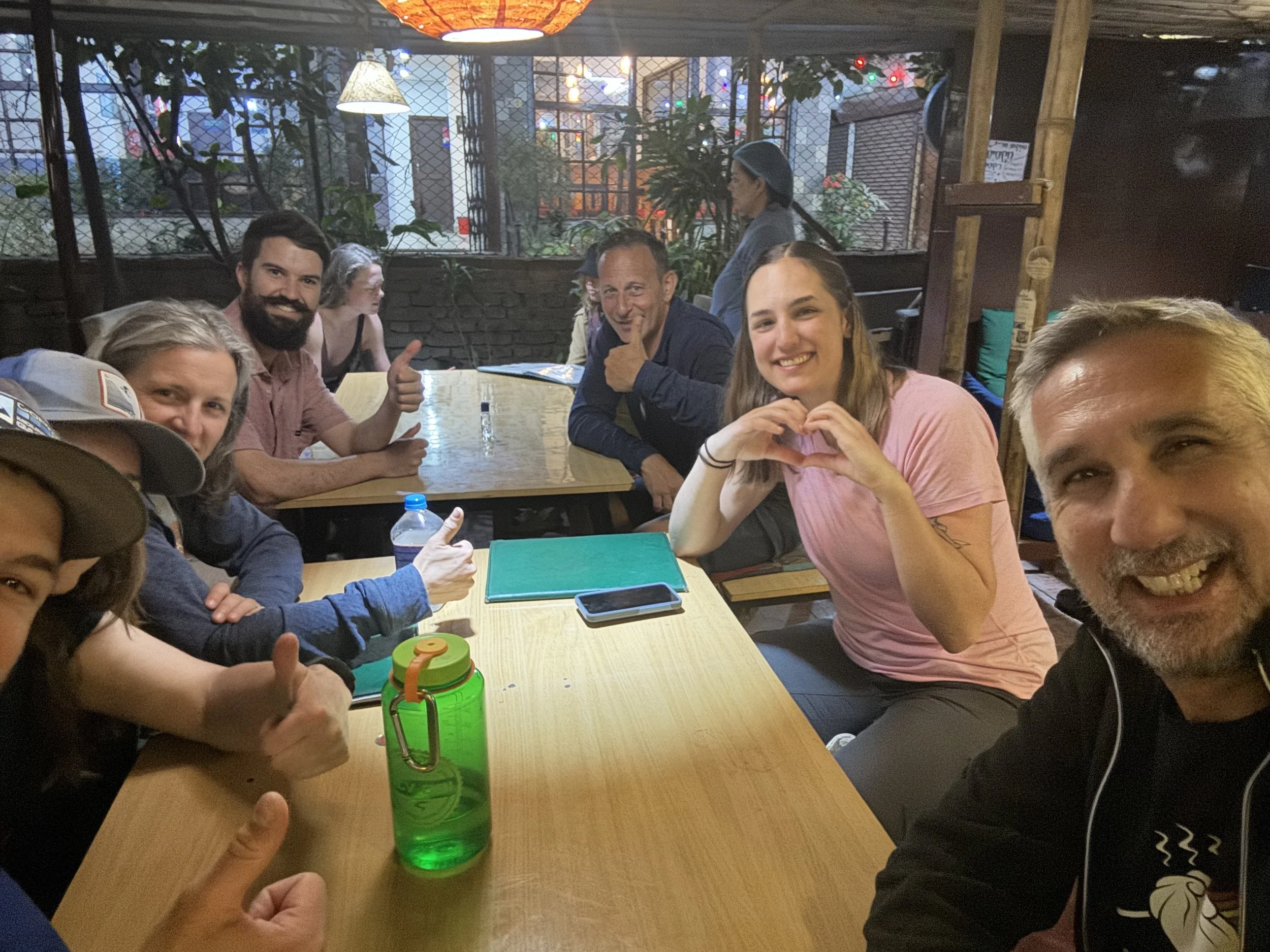
Tomorrow Rich and I would be leaving Kathmandu. So we went back to our rooms, made our final packing and went to bed.
Day 20: Kathmandu to Mumbai
I woke up early as usual, and was already dressed and ready to go down for breakfast by 7am.
I sent a message to Rich to check if he was ready to meet me. Rich messaged me to say he’d been up all night being sick! He was in a bad way, and couldn’t move from his bed! It appeared the goats cheese salad didn’t agree with him…Wow, I must have dodged a bullet!
So I was on my own for the few hours we had in the morning. I decided to go for a walk through the nearby streets for the final time, and just try and soak up as much as I could before saying goodbye to Kathmandu.

I also decided to go back to the Garden of Dreams, and just sit back for an hour or so. When I arrived it was still very early in the morning, so I practically had the entire garden to myself! What a perfect way to end my time in Kathmandu, as I lay down on the grass and reflected on everything that had happened during my entire journey in Nepal.

Rich finally met me at my hotel around 11am. Man he looked awful! He was still clearly suffering with food poisoning and I was worried if he’d make it on the plane at that point! He was unusually quiet and I could see he was just trying to hold it together. So we just sat there whilst we waited to be collected for our drive to the airport.
We said our final goodbyes to the remaining party, who had just made it back in time as our car arrived. After Rich thanked Hannah for picking the restaurant last night (haha!), we left our hotel and headed out of the city and to Kathmandu airport.
Our destination…Mumbai, India. And yes, we did have our entry Visas this time! We definitely didn’t want a repeat of what happened when we first tried to leave London for Mumbai!!
Rich pretty much kept himself to himself during the flight, and when we arrived at our transit hotel in Mumbai, he didn’t have any energy left or appetite to grab some food. So I was left alone to get something to eat at our hotel. An early night was in order, as we had our long flight back to the UK in the morning. Hopefully Rich would be feeling a lot better by then!
Day 21: Mumbai to London
Thankfully Rich appeared to have made a slight recovery from yesterday, and was able to join me for breakfast, although neither of us ate too much.
We made our way through the airport after breakfast, and prepared for the final leg of our incredible journey together.
We felt happy as we boarded the plane. We had done everything we had set out to do, accomplished something truly remarkable, and had made some great friends along the way. But we were both now ready to go back home.

After a 9 hour flight, we finally touched down in London. Rich and I were given an amazing surprise…my wife, Marissa was there, along with Rich’s wife Lindsey and their two daughters! It was such a lovely surprise, and it was the perfect way to end our adventure.
They even had a cardboard sign which they held aloft to welcome us home, what we’d accomplished….and remind us just how smelly we were! Yeah, thanks guys! :)

Rich and I said our goodbyes…ok he’s my mate, and I’d be seeing him again at the weekend, but it was still a moment…we’d been through this whole experience together and shared something truly special.
Not many people get to do what we’ve done, especially with their best friend!
Annapurna Circuit Trek…completed!!
SUMMARY
The Annapurna Circuit is more than just a trek—it's an adventure that throws everything at you: steep climbs, thin air, unpredictable weather, and moments where you wonder why you ever signed up!
But then there are the flip sides—sunrises that stop you in your tracks, laughter shared with strangers who quickly become trail family, and that unbeatable high when you finally reach Thorong La Pass.
Every sore muscle and cold night is worth it for the stories you collect, the friendships you build, and the pride that comes with knowing you did it. It’s a journey that challenges you, changes you, and stays with you long after your boots are off.
My video highlights!
That’s a wrap folks! I hope you enjoyed reading my blog.
If you did, then i’d be really grateful if you’d buy me a coffee
Until next time…
Happy Hiking!
Marc