
Dartmoor National Park Winter Traverse
Dartmoor National Park, located in Devon, England, is known for its rugged landscapes, granite tors, and heather covered moorland. Discover what happened when I attempted a 50km hiking challenge like no other, from South to North in a “race against time!”
A feature throughout Dartmoor National Park are its peat bogs!
Before I go onto the challenge itself, let’s take a closer look at Dartmoor National Park.
Dartmoor National Park
Located in Devon, England, Dartmoor National Park is characterised by vast open moorland, granite tors, and rolling hills. The landscape is dotted with heather, grasses, diverse flora, and of course its peat bogs!
The terrain is wild and rugged, with ancient settlements, and meandering rivers. There’s a strong and rich cultural heritage to Dartmoor which includes prehistoric remains, medieval ruins, and traditional Dartmoor ponies grazing freely.
The park provides opportunities for outdoor enthusiasts, such as hiking, cycling, or running. Or simply to explore this natural setting and take in its outstanding beauty.
History
Formed by granite over 300 million years ago, humans have helped to shape it over the last 10,000 years! Remnants from the Bronze age such as hut circles, burial mounds, and stone rows are scattered throughout Dartmoor. Monastic settlements such as Buckfast Abbey, and Sherberton, a deserted medieval village near Hexworthy, offer a glimpse into Dartmoor’s past communities. Dartmoor was also a significant mining area from the Middle Ages until the early 20th century. Dartmoor Prison was established in 1806, where it housed French and American prisoners of war, and later became a civilian prison.
Notable points of interest
Haytor: A prominent granite tor with stunning views
Widecombe in the Moor: A picturesque village known for its charming architecture
Princetown: Home to Dartmoor Prison and the High Moorland Visitor Centre
Tavistock: A historic market town on the edge of Dartmoor
Wistman’s Wood: A mystical, ancient oak woodland
Burrator Reservoir: A scenic reservoir surrounded by woodlands and tors
Cranmere Pool: Home to Dartmoor’s first letterbox!
Bellever Forest: Offering beautiful walks and the Bellever Tor with its panoramic views
Red Clay Volcano: On the Southern moor beside Red Lake
How to get there
Dartmoor is within easy reach from the M5 motorway in Devon, from the A30 or the A38. Journey times from Exeter or Plymouth are 30 minutes
By train: Via the Dartmoor Line
By Bus: Via the Dartmoor Explorer
By Boat or Plane: Exeter Airport, or Plymouth Ferry port
Where to Stay
North Dartmoor National Park
Collaven Manor Hotel: Sourton, Okehampton, England, EX20 4HH. Claire and Karen stayed there and said it was lovely!
Bearslake Inn: Lake Sourton, Okehampton, England, EX20 4HQ. Inn in Okehampton with restaurant and bar/lounge.
The Fountain Inn: Fore Street, Okehampton, England, EX20 1AP. Comfortable inn with business centre and restaurant.
South Dartmoor National Park
The Sportsmans Inn: Exeter Road, Ivybridge, England, PL21 0BQ. Comfortable inn near Dartmoor National Park
Cadleigh Manor B&B: Cadleigh, Ivybridge, England, PL21 9HW. Comfortable bed & breakfast near Dartmoor National Park.
Budget
YHA Dartmoor: Bellever, Postbridge, Yelverton, England, PL20 6TU. A comfortable hostel with restaurant and bar/lounge
The Dartmoor Winter Traverse
Organised by Climb South West, the Dartmoor Winter Traverse 2024, is a 50km ultra challenge event (with a 30km option) where participants hike continuously through the remote parts of Dartmoor from South to North. It’s an incredibly tough challenge that really pushes you out of your comfort zone!
It’s now in its 5th year, and entry into the challenge is very limited, on a first come basis, with a resulting waiting list.
In my opinion the course is predominantly designed mainly for runners. I say this, as the event organisers are all runners, and the cut off times for walkers are extremely tight! (A lot more on that to come!).
Route Description
The route passes Red Lake and the sources of the rivers Erme and Plym, (don’t expect to keep your feet dry!) After a welcome break in Princetown, it continues to some wild locations on the North Moor including: Roos Tor, Tavy Cleave and Chat Tor. From here, the route picks up the Rattlebrook dismantled railway before descending to the finish in Meldon.
Difficulty
Moderate to Tough!!
Weather: !s always a factor on Dartmoor but even more so in February. This year saw more rain fall in the week leading up to the event itself than is typical for the whole month! the night before it snowed as well!
Time: There is also the small number of daylight hours to consider. This resulted in the organisers placing very strict cut off times to reach the first and second checkpoints.
Terrain: Rugged, peat bogs, high streams, long grasses, and open moorland. Plus 11 big hills to ascend and descend thrown into the mix!
Distance
50km / 31 miles
Elevation
3,051 ft ascent / 2,625 ft descent
Highest Point / Lowest Point
1,778 ft / 410 ft
Sections
Start – South Brent Village Hall, TQ10 9AQ
RS 1 (20km) – Princeton Community Centre, PL20 6RF
RS2 (35km) – Lane End Car Park, PL19 9NB
Finish (50km) – Meldon Village Hall, EX20 4LU
Event Day Timings
5.15am: Registration for coaches at Meldon Village Hall
5.30am: Coach departs, near Meldon Village Hall
6.15am: Registration opens at South Brent Village Hall
7.15am: Safety briefing
7.30am: START for 50km walkers and runners (9.30am for 30km)
Cut off at Princetown (20km): 12.30pm (changed to 12pm on the day)
Cut off at Lane End Car Park (35km): 4.30pm (changed to 4pm on the day)
Mandatory Kit
Base Layer (long sleeved, thermal properties)
Trail shoes / Walking boots
Waterproof jacket and bottoms
Mobile phone
Rucksack with additional clothing
Hydration system (bladder or bottles, minimum capacity 1 litre)
Survival bag (Bivvy bag) – Foil or plastic
Basic first aid kit (minimum 1 x wound dressing and selection of blister plasters)
Warm headwear
Gloves
Whistle
Headtorch with spare batteries/spare headtorch
Nutrition (packed lunch, energy foods, gels, bars etc.)
Route Map
OL 28 Dartmoor (1:25,000), or BMC Dartmoor (1:40,000) maps
You can download my route here Marc’s OS Maps Route
BLOG: The Dartmoor Winter Traverse (Part 1)
When I was first asked by Claire, a friend from the Ultra Challenge circuit, if I’d be interested in participating in a 50km challenge event in Dartmoor National Park, in February, with traditionally wintery wet weather, through open moorland and peat bogs, and crossing streams deep enough to come up to your knees…oh and without the usual pink coloured arrow markers along the way that aid in which direction you should be heading…in my head I was thinking…”are you crazy?” But to my surprise I actually said ‘’Sure…count me in…what’s the worst that can happen?’’
We both then persuaded a friend each to join us, Karen and Simon. So Team DIAD (Dartmoor in a Day) was formed.
Between us it’s safe to say we have loads of experience in ultra challenge hiking events. But none of us had quite considered taking on something like this particular challenge before. We had all completed many 50km and 100km challenges. But DIAD In Winter, presented something slightly different to what we’d been accustomed to, which I guess we were all excited if not a little nervous in discovering if we’d be up to the challenge!
So on a cold and dark morning on Saturday 24th February 2024, It was time to find out!
Making our way to meet our coach at 5am!!
Event Registration
Like most ultra challenge events, it was an early start, my alarm going off before 4am! Time to wash, tape up my feet, dress, double check my kit, grab a coffee, and head out the door by 4.45am.
It was a short drive to Meldon, where parking was available at the Reservoir Car Park. From there a 10 minute walk down to Meldon Village Hall, where we’d be getting on a coach with up to 60 other weary eyed participants, to take us to South Brent, where the challenge would begin from.
The coach left at 5.30am and we arrived at South Brent Village Hall an hour later. Time for registration, kit check, and event briefing.
The kit check was something we hadn’t experienced before. But I actually think that was smart by the organisers to have in place. We had been informed by email what the mandatory kit must include, and they made sure we all had extra layers, torch, and also importantly, a Bivvy Bag (survival bag). Now writing this post the event, I can absolutely see why this was essential!
I mentioned earlier that this event was limited in its number of participants, and for good reason. Although I don’t have exact official participant numbers, they were approximately as follows…
90 participants for the 50km, and around the same for the 30km.
Out of the 90 x 50km participants, It appeared to me that only around 20 or so would be walkers, the rest were runners.
For us walkers, this meant that we’d be at the back of the pack for the duration of the event! Something we weren’t used to!
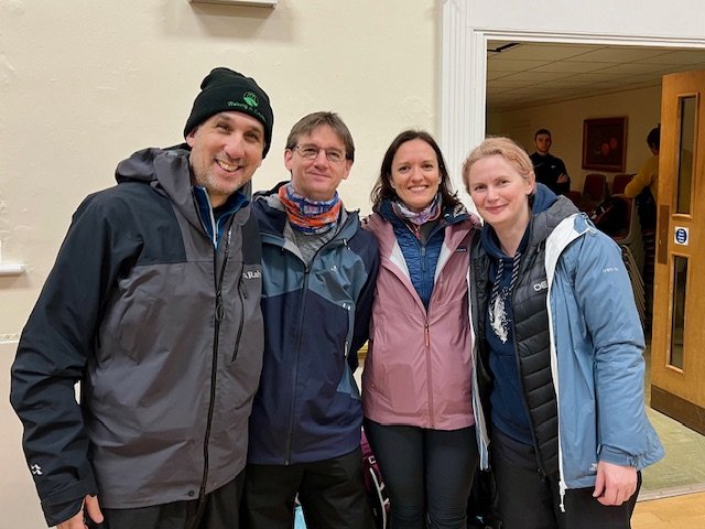
Team DIAD: (Left to right) - Marc, Simon, Karen, Claire
STAGE 1: South Brent to Princetown (20km)
7.30am: Start of the Dartmoor Winter Traverse
No sooner had we set off, and we were passed by a steady stream of runners, and just like that, we were at the back of the pack. But we had our mission faces on and we set off at a good pace, knowing we’d need to make the most of the relatively easy going tracks and paths before the real challenge of the moors would ultimately slow us down.
Let’s pause here for a second whilst I quickly explain our game plan…
Let me take you back to the strict cut off times (this would always be at the forefront of our minds throughout the day).
The first cut off time would be 12pm at the 20km rest stop in Princetown, with the second cut off being 4pm at the 35km Lane End Rest Stop.
Putting that into context, and into simple layperson’s terms…we’d need to get a move on!
We know, given normal event circumstances, hiking 20km in 4.5 hours is doable. Yes, it’s a long stretch, but doable. Then that’s followed by another long 15km stretch which which we had thought we’d need 3.5 hours to make it in time. Tight, but again doable.
But when you add in the rugged terrain, peat bogs, streams, oh and 11 big hills, all of which would slow us right down, we would need to walk around 5.5km/hr-6km/hr, with minimal rest, to make up for lost time…for the entire day!
At this stage, we weren’t even thinking about the last 15km. Our thoughts were solely on making it to both cut off times.
Ok, got it? Great! Let’s continue…
So back on the trail…we were off and had hit a good stride. For now, despite the cold and light drizzle, the going was pretty easy, with typical park gravel paths and dirt tracks that ran in between fields on either side.
We followed the path, through a series of gates and over a stile or two, as we slowly ascended a little higher, and up towards the moors.
Reaching Shipley Bridge, with the River Avon running to our right, and the colourful hues of gold, green and brown all around us, we were now heading into the start of our real adventure!
We were even treated to the delightful sight of the Dartmoor ponies, as they grazed happily nearby!
It had thankfully stopped raining, for now, and pockets of sun were starting to creep their way through the clouds.
By the time we reached the start of the South Moors it was 8.45am. We’d been making good time. But this is where it all got a bit interesting! Let the fun of the bogs and marshes begin!
Despite the sun now breaking through, it felt bitterly cold as we reached the higher plains of the Zeal Tor Tramway. It’s a vast open moorland, at around 300m elevation, where you’re totally exposed to the elements.
We’d been pushing it for the past 90 minutes, and decided to pause momentarily to take in some water, and have a quick snack. Just stopping for a couple of minutes and it was noticeable how quickly the cold took a hold! But it was an absolutely stunning vista!
We continued making our way through the wet, boggy ground, mindful of each step, with boots occasionally refusing to break free of the glue-like moorland.
There was a small group of walkers behind, accompanied by a couple of event Mountain Leaders. They were extremely knowledgeable, as all were local, and had vast experience of traversing Dartmoor National Park many times. Very handy to have them close by! They also knew the importance of keeping up a fast pace, and throughout the day they would push us, driving us forward so we’d have the best chance of making it to our respective checkpoints before the cut offs.
The Mountain Leaders, as all experienced trail runners as well, would switch between walking and running throughout the day, depending on where they were needed. Quite amazing!
We’d broken free of the small pack behind us, and felt confident in following the rough path we were taking towards the peak of the current climb at approx. 450m. We headed slightly left and down towards the Redlake Tramway.
At this point one of the Mountain Leaders came running towards us as we had apparently taken a wrong turn! We should have continued in a straight line. However, having made it down to the tramway, we would eventually join the route up again, so we continued on the easy going track, which felt like a relief to be walking on solid ground, albeit not for long!
We re-joined the course trail, bearing left, as we reached a sight I hadn’t been expecting…a volcano! Ok, not in the grand scale of Kili, or Cotopaxi, but still, a volcano…In Dartmoor!
We were now on Abbots Way. The ground we were now walking on was extremely slow going. Rough grass, with heavily boggy ground. It was a long stretch, as we passed Red Lake and towards Middle Mire.
So far, despite the sometimes wet ground we’d been walking through, our waterproof socks hadn’t really been tested, yet. That was about to change.
We reached the first in a series of water troughs, which there was no choice but to wade through.
Despite feeling the odd sensation of water filling my boots, my Sealskinz waterproof socks were holding up! My feet felt dry…for now at any rate!
Safely through, we ploughed on. There was no time to lose, as it was now 10am, and we were still a long way from our first checkpoint at Princetown.
15 minutes later, after having squelched our way through more and more boggy ground, we were confronted by a bigger challenge. A deep stream, with no option but to step down into. We had considered looking to cross over some rocks which protruded over the waterline, but we were told, wisely, by our Mountain Leader not to, as that would pose a danger, and we’d need to climb down into the cold water to cross. We took a meek peak…
Stepping into the water, as it came up to my knees, it was then I knew my socks would be severely tested! Would the membrane around the top of the socks hold? I wasn’t sure, but there wasn’t any time to think about it, so we kept going.
The pattern of crossing through watery pools, and traversing wet, boggy grassland continued, on and on, for the next hour.
Eventually we made it through the wet moorland as we reached the more solid ground of Ivybridge Lane. Time had got away from us. We were still 5 km away from Princetown and we had 45 minutes to make it before the first cut off!
As we approached a disused farm called Nun’s Cross Farm, with Siward’s Cross in front of it, we passed several young adults all clearly taking part in the Duke of Edinburgh Award, noticeable with their heavy backpacks, and maps.
The weather was also against us now. It started to rain quite hard, followed by hail, driving into our faces.
But where there is rain followed by sun, there’s always a rainbow!
Claire and Karen were on a mission! Seemingly loving the firm track we were now on, and knowing Princetown wasn’t far away, they steamed ahead of me and Simon.
It wasn’t long before we could see Princetown ahead. Keep going…we’re nearly there now. I was longing for something to eat and drink, and put my feet up for a while!
We headed into Princetown, as it was approaching 12pm. First walking past the National Park Visitor Centre, as we followed the orange signs towards Princetown Community Centre.
We made it to Rest Stop 1 at 12.04pm. 4 minutes late. But fortunately not too far past the cut off time to be disqualified! Time to get a hot drink, grab a sandwich out of my bag, and rest!
However, one of the Mountain Leaders said almost immediately, “right we’ll be leaving at 12.20pm”. What? Just 15 minutes break? I said “No!” To which he gave me a quizzical look that I read as “you don’t have a choice pal”. He wasn’t joking.
The joy of reaching the rest stop was immediately replaced by frustration, and concern, knowing that yep, this is a real test of endurance! Suck it up, and get on with it!
To make matters worse, the runners, or as I like to call them, “greedy little hobbitses”, had consumed the majority of the little food that was on offer. So, after inhaling a bread roll and having a quick tepid cup of tea, the remaining walkers, and there weren’t many of us now (some would have missed the cut off), got our rucksacks back on and ventured out once more for stage 2.
STAGE 2: Princetown to Lane End (35km)
12.20pm: We departed the Community Centre, this time as a group of around 10 walkers, plus Mountain Leader.
It was raining, and during the relatively short break, our bodies had cooled down. So Team DIAD led from the front, as we were keen to get off to a quick pace.
There had been some discussion whilst we were eating whether we would go any further past the 35km checkpoint. The morning had been really gruelling, and as a result we had burned a great deal of energy into the first 20km. We were determined at least to give it everything to get to Lane End in time, so that the decision to continue or not would be in our hands.
After walking through Princetown, we took a right turn, and 10 minutes later we were back in the wide open spaces of the moors. This next section would stretch for around 5km, on an easy going gravel track. So we used this as an opportunity to get some speed in our legs!
We managed to knock off that 5km in 45 minutes, and it felt great to believe we had just under 3 hours with only another 10km to reach our next cut off point at Lane End…Or so we thought!
But as we diverted right and back onto the Moors, the challenge once again revealed itself! More bogs and deep streams would slow us down, and there were still plenty of hills to navigate too!
The group had re-formed now. We had ascended to around 400m, with King’s Tor now visible to our left, before we made our way back down, towards Merrivale, and a stretch of road that ascended steeply.
It was a slow but steady slog as we made our way up the road, hugging the stone wall as best we could. The Mountain Leader told us that once we reached the brow of the hill, we would make a right turn, and take a short break there to gather some strength before the next big hill!
So we rested for 5 mins taking in some water and snacks. Feeling a little refreshed we slowly began the ascent. We passed a deserted looking Merrivale Quarry to our right, and kept ascending slowly, making our way towards Middle Staple Tor, 450m. We were starting to spread out again. I felt energised meanwhile, and managed to reach the plateau ahead of the majority of the group. Partly to just get this hill done, the other to use it as an opportunity to get some Ibruprofen out of my first aid kit, whilst I had some time whilst waiting for others to make it. Although I felt fairly strong, I was also conscious I needed to take in a lot more liquids, so I duly took some on board.
Above photo (courtesy of Claire): Simon and me ploughing on up the hill, behind our Mountain Leader.
Once the group as all together, we set off again. To our right was Great Staple Tor, with its granite tors protruding into the sky, and further along Roos Tor. We climbed towards the first, carefully stepping up onto the rocks, and through the other side. Then made our way downhill and up again towards Roos Tor. From there looking back, we could see Plymouth in the distance.
Great Staple Tor
Roos Tor
Moving on once more, we headed first downhill on Peter Tavy Common, before ascending once more to the Langstone Stone Circle.
That last stretch had taken a great deal of time. It was now approaching 2.45pm. The last 2.5 hours since we had left Princetown had seemed to disappear. But by my calculation we had 5km to go to make it to Lane End (35km checkpoint).
No sooner than I had highlighted this to the group, feeling positive that we could quite easily knock off the next 5km before the cut off, than the Mountain Leader said it was in fact at least 7km to Lane End, and that it was in fact a 37km checkpoint, not 35km as indicated!
Game changer?
Although I held on to the belief that he was wrong, I think at that point we realised even with our speed it would be a huge challenge now to make it.
Simon had said to me he was thinking of calling it a day when we reached Lane End anyway. I wasn’t sure about Claire and Karen’s intentions either. But I do know in these challenge events, we all experience highs and lows, and you can easily talk yourself into thinking you’ve had enough and it’s time to stop. These thoughts had also crossed my mind.
However, although I was exhausted from what felt like we’d been marching all day long, I didn’t feel like quitting at all, and I did my best to keep up my self-belief as we continued to push on and on towards Lane End.
We were pushing as fast as we could. Just keep walking.
3.20pm and we were now heading towards Bagga Tor, 370m, and then downhill towards Coffin Wood.
3.40pm: Coffin Wood (below)
3.50pm: River Tavy (below)…10 minutes until cut-off!
4pm: River Tavy crossing (below)…cut off time!
We had now passed 35km, then 36km, and had reached the 4pm cut off time. The 2 questions now were; How much further until Lane End? And would we be allowed to continue?
The answers to both questions came 14 minutes later.
We arrived at Lane End at 4.14pm. Not 35km, 36km or even 37km….but at 38km!
Ok, so first thing on my mind was where’s the food? Just a few flapjacks left. Those greedy little Hobbitses (the runners) had been at it again!
Then we discovered our fate…
Our Dartmoor Winter Traverse was over!
They were very strict about the cut off times! At first I was in a bit of disbelief! I still felt good, and confident of carrying on for the last 12km (despite the biggest hill of the day coming straight after). But I got it. I understood the dangers of anyone being stuck out in the moors once it got dark. And we would definitely be out in the dark if we were permitted to continue.
So, we drank our teas, ate our flapjacks, as we waited to be transported back to Meldon Village Hall.
The Bus of Broken Dreams
The return to Meldon Village Hall
The four of us were joined by a couple of the other remaining walkers, Paul and Ben. We all chatted for a while as the initial disappointment of stopping at 38km, turned to pride as we realised just what we had achieved today.
38km of continual walking at high speed, with only 1 x 15 minute rest in between. Through bogs and streams, wading through high waters, ascending 9 out of 11 hills, with a total of over 3,000ft / 900m+ of elevation. It had been a beast of a challenge, and I take my hat off to the few walkers that did manage to complete the full 50km in the permitted time. I don’t think there were many!
So the 6 of us climbed aboard the Bus of Broken Dreams (Karen’s brilliant remark!). We chatted and laughed as we recounted the day’s events, all looking forward now to some hot food, and rest!
When we arrived, we were greeted by the Event Organiser, Justin. He shook our hands and was full of praise for what we had achieved! That was really great to hear.
He then presented us with our medals. He said we had definitely earned them! He was right!
So the 6 of us stood outside the Bus of Broken Dreams (I mean where else?) to have our photo taken with our medals, hanging proudly.
Left to right: Marc, Paul, Ben, Karen, Simon, Claire
And a very tired looking Marc!
Results
90 participants took on the 50km challenge…(Approx. 70 runners)
8 retirees at 20km (Princetown)
76 completed (only a handful of walkers completed)
Winning time: An astonishing 5hrs 26mins!
Although I doubt I’ll enter the Dartmoor Winter Traverse again (unless Claire wields her powers of persuasion once more), I can’t wait to go back there one day, albeit for a more leisurely hike!
Hmm…hold on a sec!! There’s more…
The Dartmoor Winter Traverse (PART 2)
On Saturday 22nd February 2025, our team DIAD did head back to Dartmoor…yes - Claire did manage to persuade me!…for what is called…
“The Revenge of the Bus of Broken Dreams”
So, sometime afterwards, Claire said “so are going back to finish this off then?
To be honest, i just found myself saying, “ooh, that sounds awesome!” and i booked my place instantly!! What??? My short term memory loss had well and truly kicked in! Damn Claire and her hypnotic powers of persuasion!
06.45am on the day of our return to Dartmoor, this is me thinking…’what have i done?”

We all arrived the night before, and met up for a bite to eat at the Highwayman Inn in Okehampton. OMG…it has to be one of the quirkiest pubs i’ve ever been to! Here’s just a few snapshots, so you get the drift! If you’re ever in the area, it’s a must!


THE BLOG
Saturday 22nd February 2025
Our challenge today would be to take on the 2nd half of the Dartmoor in a Day, which would start from Princeton, and finish back in Meldon.
The route had been slightly altered from the previous year, which meant that the total distance would be 28km…much more manageable we guessed! We also guessed that we wouldn’t have any problems with the cut off times this year! No greedy little Hobbitses to worry about!
So, after our coach journey down to Princeton for registration and bag check, Team DIAD were raring to go…

Section 1: Princeton to Lane End
09.30am
The weather forecasted for today was looking reasonably good, considering it had been raining heavily the past few days, and very strong winds of 50mph were expected tomorrow! So we were hoping the weather gods would be right today, and we’d dodge a bullet!
However, the morning had brought with it some low, freezing fog, and it was a cold start when we finally set off on our Dartmoor Winter Traverse!

After heading out of the community centre, the change in route meant we’d be heading right along the road, followed be a left, and it wasn’t long before we had our first (of very many) ascents of the day, leading us up onto the Moors.


Before we had set off, we all made a bet on how long it would be before we had to contend with getting our boots stuck in the bogs. Times ranged from 30mins to an hour (we had thought we’d be on the road for some time early on).
In fact, it only took 15 mins until Karen got her boots firmly enveloped in a muddy, and very watery bog!

I didn’t fare any better…

Safely, and eventually up onto the brow of the hill, we passed the radio mast, and were up onto a track, and began walking, until we turned left and onto the moors.
Our spirits were high at this point, and we kept up a good pace, despite the uneven ground, with some long and thick grass that has grown over the years.


Eventually, we reach a stile, climb over, and head onto a section of road, where we head left, towards the quarry.


10.30am
We’ve now rejoined the route from last year, and after the long and steady ascent up the road, we turn right, and take a short break, to take in some water and a light snack.
A long climb is ahead, which is all too familiar…the ascent up to Middle Staple Tor (452m), and along to Roos Tor (454m).


11.15am
We then followed the extremely long and wide open moorland, which seemed to stretch on forever! An endless trudge, with the occasional bog here and there to keep our feet guessing where and where not to tread.
At one such bog, we watched as one poor runner tried to jump over a bog, and landed deep and firmly stuck, much to the amusement of his friends, who were only too happy to take photos of his plight!
We also had to help one poor woman who also got herself stuck!


We continued on, and the bogs and moors receded as we began to head downhill, and towards the woodland. At one point a number of us took a wrong turn and headed into some woods, before we were fortunately seen by one of the marshalls, who got us all back on track. But it was a pleasant diversion nonetheless, with dozens of moss covered roots paving the ground.

Eventually back on track, we followed the River Tavy, knowing that our first mission…to reach the Bus of Broken Dreams…wasn’t too far ahead.


13.05pm
Rest Stop: Lane End
So, we had made it…to the Bus of Broken Dreams…and as we had expected, the aforementioned bus was indeed standing there…only this time we had beaten it!
We marked the occasion by honouring the bus, in the most dignified way we could muster…
It was also a delightful surprise and relief to see that those greedy little Hobbitses (aka the runners) hadn’t gone through all of the snacks this time! Joking aside, we had expected to fare better, seeing as we were well ahead of our cut off time compared to last year!
The sun was out now, and we had worked up a sweat. So, we paused for a short while, to take on board some much needed fuel - a few cups of cola for me, a sandwich, and some sweets that Karen handed out.
Our next section…was unfinished business!
Section 2: Lane End to Meldon Village Hall
1.30pm
From our rest stop, we knew what lay ahead of us…or so we thought!
We could see the peak of the hill we would be faced with, but at that point, i don’t think any of us truly realised just how much of a test it would turn out to be!
Starting out, all felt good enough, as we crossed a small stream and began the next section of our challenge.

Then the ground began its ascent…on and on it went…for 30 minutes…it was a beast!
Simon and Claire were well ahead, seemingly unfazed. Karen and i however had to stop to take off our jackets and i also removed my fleece, as we were sweating loads!
Reaching the top, it had been 1 mile of ascent!!
Great Links Tor (582m).


That beast done, it was immediately followed by another! a shorter, but far steeper climb.
Hunt Tor (562m), and along to Gren Tor (512m).
2.30pm
It had taken an hour of steady and sweaty climbing, but we had at last completed the final large hills of our challenge!

The next leg of our journey started off ok, as we were heading downhill. But as ever, the terrain had other ideas. Clumps of uneven grassy mounds lay everywhere, and it was a struggle not to twist an ankle as you had to turn this way and that.
After 30-45 minutes we reached a break in the moors, which was divided by a track, with tramlines running down as far as the eye could see. The four of us took a much needed short break, to take in some more fluids and prepare for the final push towards the finish.
Once off, along the track we passed dozens of shallow pools of water, which were filled with frog spawn. The pools of water would need a fresh downpour of rain to help any newborns chance of survival. No doubt the storms the day after would have brought that chance of luck with it!


Another 30 minutes passed, as we headed further down and off the moors, and into more green, open pastures. We passed several Dartmoor ponies, who were quietly grazing, and a couple of them came towards us as they stopped by a shallow pool to drink.
Then we could see Meldon Reservoir in the distance. We were nearly there!


THE FINISH
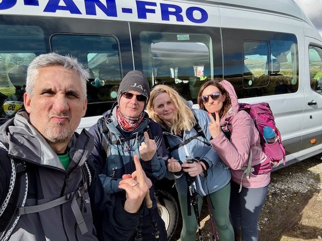
A further 20-30 minutes passed, as we finally came to the end of the fields, and exited onto a road in Meldon village. Just a few strides more, and Team DIAD - (left to right in the photo) - myself, Simon, Karen, and Claire, crossed the finish!
4.35pm
28km, in a time of just over 7 hours.

No medals were handed out this year. For environmental reasons, the organisers had decided to enlist the help of a local business to produce wooden coasters, and another local brewery had produced a pale ale with the Dartmoor in a Day logo on the can. Nice touch!

Dartmoor Winter Traverse (Part 2) - complete!
We had finally completed the Dartmoor Winter Traverse, but more importantly - we had achieved our Revenge of the Bus of Broken Dreams!
Final note - although once again i had said aloud that this was the LAST TIME you’d get me on Dartmoor - by the time we’d all had our refreshments at the village hall, we were busy planning our next visit - for the Dartmoor in a Day Summer Traverse! :)
Until the next time
Happy Hiking!
Marc
If you enjoy my blogs please feel free to buy me a coffee!