
Edale Skyline Challenge

The Edale Skyline Challenge is one of my favourite hikes in the UK, and considered a rite of passage for many avid hikers and adventurers, myself included!
With it’s rugged terrain, stunning views, and the sense of accomplishment you get from conquering numerous peaks, the Edale Skyline route is an unforgettable experience.
Description
Distance: 32km / 20miles
Walking time: 8-10 hours
Elevation gain: 1,250 metres / 4,100ft
Main Highlights (there’s many!): Ladybower reservoir, Win Hill, Brown Knoll, Hope Cross, Kinder Scout, Lord’s Seat, Mam Tor, The Great Ridge, Lose Hill
Start Point: There are various route options, but I’m going to take you from Hope Train Station. Postcode S33 6RD, or if you use What3Words you can find it at misty.differ.ages. You can pay via the Ringo app, and parking for the day costs £1 (Mon-Fri) or £3 (weekends, or Bank Holidays)
Facilities: It’s best to use the loo if you can before you head off, as there’s no toilet facilities during the whole route! Best place nearby is a public toilet at Hope Car Park S33 6RS (opens at 8am)
What gear to bring: Take a rucksack, with plenty of water (2-3 litres), and food/snacks. Also take spare layers, as with British weather, it can be unpredictable! In the Summer months, wearing hiking shoes or trail runners will be fine, but later in the year, I would advise wearing waterproof hiking boots, as it can get quite muddy
Marc’s OS Maps route
So, now that you’re set, let’s go!

Hope Station Bridge, and the start of the Edale Skyline Challenge!
Route description
You begin your Skyline challenge from Hope Train Station, and across the bridge (see photo), then taking the footpath on the other side. You enter a field, and make a right turn, over a small wooden bridge, and then pass through a couple more fields.
There’s a couple of turns left then right, which takes you onto a path that takes you up towards Win Hill, with some incredible views of Ladybower Reservoir. The whole way up and beyond the purple hue of heather is as far as the eye can see! It’s a real spectacle!
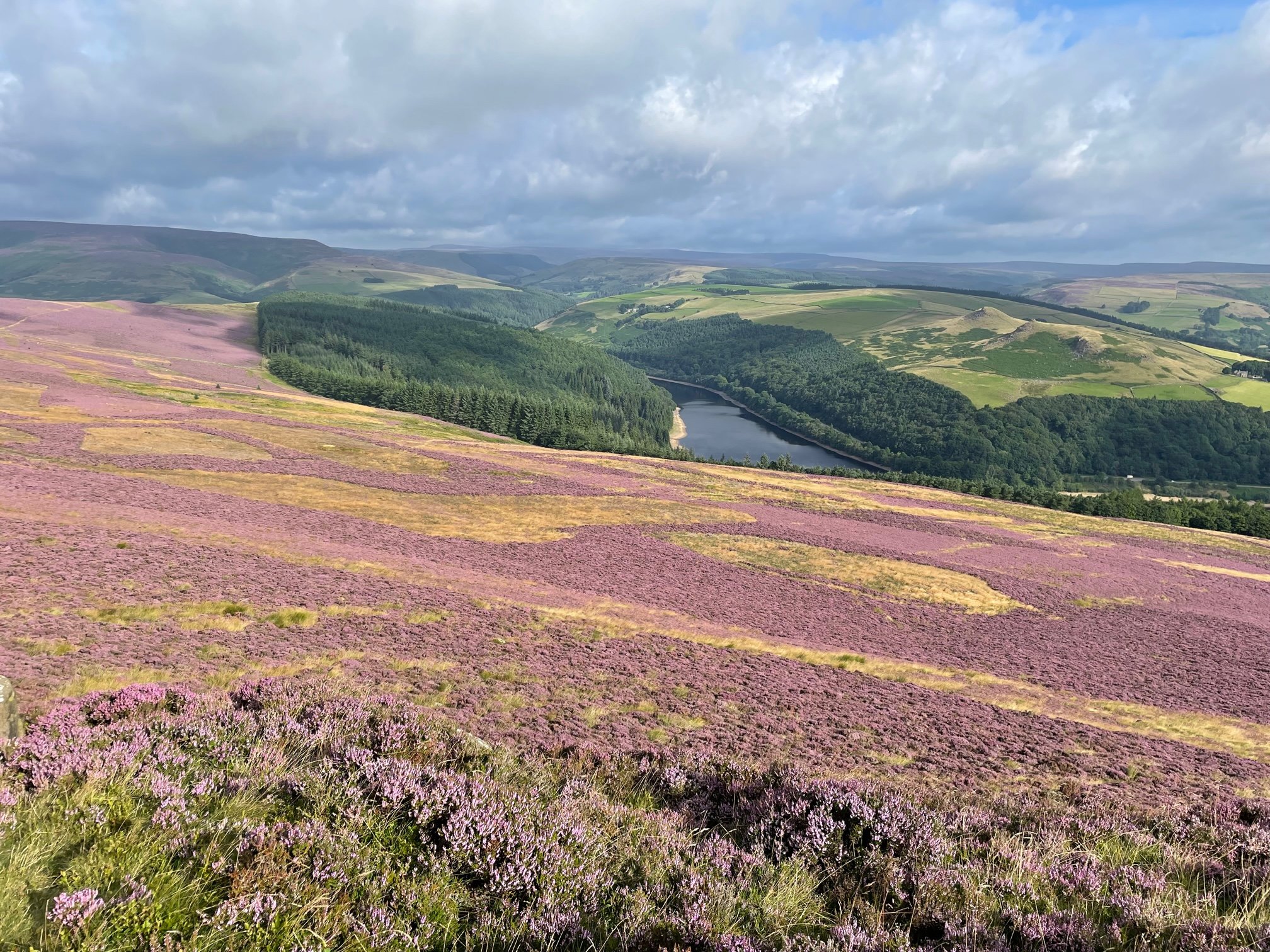
The unmistakable purple heather provides a dramatic backdrop looking down towards Ladybower Reservoir
Keep heading uphill (to the left), and you’ll soon reach Win Hill summit ahead, which is marked with a trig point. Congratulations! Your first peak is done!

Win Hill trig point! The first peak of the Edale Skyline Challenge done!
After snapping up some photos from this incredible vantage point, it’s time to move on.
We then descend down on to the path, which continues on for a few kms. This takes us past some woods, and down a track, until we reach Hope Cross.
This is a lovely part of the route, as it offers some beautiful views of the surrounding hills in and around Hope Valley.
Enjoy that while you can, as after that there’s an ascent we must take up to Crookstone Out Moor!
Once at the top, we continue along the ridge, and there’s the option of going up Grindslow Knoll. We’re now near Kinder Scout, which is an area I really love! All the huge boulders make it a tempting playground if you’re feeling brave enough to perch on any of the higher ones that hang over the edges! (Please take good care if you’re like me, and find it hard to resist those temptations!)

The rock pillar was too much of a temptation for me to resist, even if i was hanging on for dear life!
When you’re ready to continue, you head west towards Crowden Tower. We’re now at our halfway point. Time for a spot of well-earned lunch? You bet!
We make our way through the boulders, and eventually we make it to the flagstones that lead on to Noe Stool. From there we head down a single track to a large cairn.
At this section we now join the Pennine Way for short time, and we keep following this path in the direction of Brown Knoll and another trig point! Awesome! We’re ticking off those trig points!
Keep following the track, and head up towards Lord’s Seat. There’s a path that takes you down towards the road, before you begin the climb up Mam Tor.

At the foot of Mam Tor, about to make the ascent

Mam Tor summit!
From Mam Tor, we now continue on making our way towards our final summit, Lose Hill. On our way, one of the most iconic vistas on this route, is the view of Lose Hill from the vantage point of this gate below (undoubtedly the most photographed gate in the Peak District)…
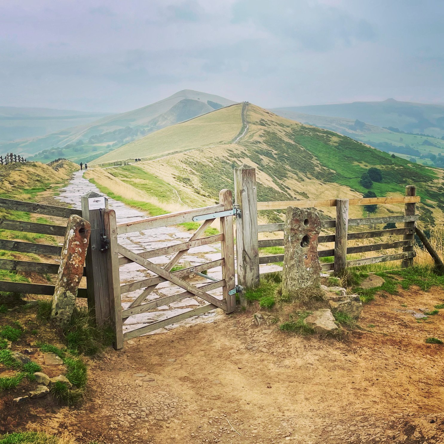
The iconic view towards Lose Hill!
We follow the Great Ridge all the way, climbing over a stile on our ascent up over Back Tor, to our final summit Lose Hill.
Up and over this stile to make your way up Lose Hill

The toposcope at the summit of Lose Hill, with compass points engraved on it marking all the various peaks you can see in the distance
It’s time to head off once more, onto the final section of our challenge, as we make our descent down towards the road, and to Hope Station.
We make it back to Hope Station, and have now completed the infamous Edale Skyline Challenge!
Summary
It doesn’t matter if you’re a seasoned hiker or someone that’s simply seeking an unforgettable adventure. This route offers anyone that’s up for the challenge an opportunity to explore the Peak District in a completely different light, where you can embrace and fully savour all the breathtaking landscapes the Edale Skyline Challenge has on offer.

There’s nothing like taking on the Edale Skyline Challenge with a group of great hiking friends!
I hope this inspires you to take on this unique and epic challenge for yourself!
As always, happy hiking!
Marc
If you enjoy my blogs feel free to buy me a coffee!